IMAGES TAKEN NEAR TO
Draycott Road, SWINDON, SN4 0LS
Introduction
This page details the photographs taken nearby to Draycott Road, SN4 0LS by members of the Geograph project.
The Geograph project started in 2005 with the aim of publishing, organising and preserving representative images for every square kilometre of Great Britain, Ireland and the Isle of Man.

There are currently over 7.5m images from over14,400 individuals and you can help contribute to the project by visiting https://www.geograph.org.uk
Image Map
Images are licensed for reuse under creativecommons.org/licenses/by-sa/2.0
Notes
- Clicking on the map will re-center to the selected point.
- The higher the marker number, the further away the image location is from the centre of the postcode.
Image Listing (15 Images Found)
Images are licensed for reuse under creativecommons.org/licenses/by-sa/2.0
Image
Details
Distance
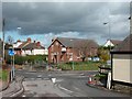
1
![Chiseldon buildings [1]](https://s1.geograph.org.uk/geophotos/06/42/46/6424669_33ff1da8_120x120.jpg)
Chiseldon buildings [1]
Named after Major General T.C.P. Calley CBE MVO of nearby Burderop Park is the memorial hall built in 1933. Derelict for 15 years after the British Legion moved out the hall was renovated and brought back into use as the village hall in 2009.
Chiseldon village was founded by the Saxons and lies 3 miles south of Swindon on the Roman road from Cirencester and Mildenhall, now the A346. An agricultural village until the late 19th century but now most workers commute to Swindon. In 1914 a large military camp was built south of the village with the camp population being greater than that of the village. The military presence continued until 1961.
Image: © Michael Dibb
Taken: 11 Mar 2020
0.16 miles
2
The Oddfellows Hall, Chisledon
This was built as an Oddfellows hall in 1879, in more recent years it has housed the library, it's currently empty, looking for a new inhabitant.
Image: © Martyn Pattison
Taken: 7 Apr 2005
0.18 miles
3
![Chiseldon buildings [3]](https://s3.geograph.org.uk/geophotos/06/42/46/6424675_2e0aed2d_120x120.jpg)
Chiseldon buildings [3]
Now the Chisledon Smokehouse, this was until 2018, The Patriots Arms.
Chiseldon village was founded by the Saxons and lies 3 miles south of Swindon on the Roman road from Cirencester and Mildenhall, now the A346. An agricultural village until the late 19th century but now most workers commute to Swindon. In 1914 a large military camp was built south of the village with the camp population being greater than that of the village. The military presence continued until 1961.
Image: © Michael Dibb
Taken: 11 Mar 2020
0.19 miles
4
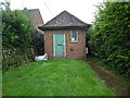
Former Telephone Exchange, Chiseldon
Situated in New Road SN4 0LU, this former TE dated from the GPO era, ie before 1969 and appears to be disused. It was replaced by the present TE a short distance away during the 1970s.
Image: © David Hillas
Taken: 16 Aug 2019
0.20 miles
6
![Chiseldon buildings [2]](https://s1.geograph.org.uk/geophotos/06/42/46/6424673_f784eab5_120x120.jpg)
Chiseldon buildings [2]
Built as an Oddfellows Hall in 1879, this building housed Chiseldon Library until 2004. Now residential accommodation.
Chiseldon village was founded by the Saxons and lies 3 miles south of Swindon on the Roman road from Cirencester and Mildenhall, now the A346. An agricultural village until the late 19th century but now most workers commute to Swindon. In 1914 a large military camp was built south of the village with the camp population being greater than that of the village. The military presence continued until 1961.
Image: © Michael Dibb
Taken: 11 Mar 2020
0.22 miles
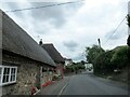
7
![Chiseldon houses [1]](https://s2.geograph.org.uk/geophotos/06/42/46/6424678_733f7128_120x120.jpg)
Chiseldon houses [1]
A glimpse from New Road of number 35. Dated 1749, this thatched cottage seems in poor condition. There is a 19th century rear extension. Listed, grade II, with details at: https://historicengland.org.uk/listing/the-list/list-entry/1023327
Chiseldon village was founded by the Saxons and lies 3 miles south of Swindon on the Roman road from Cirencester and Mildenhall, now the A346. An agricultural village until the late 19th century but now most workers commute to Swindon. In 1914 a large military camp was built south of the village with the camp population being greater than that of the village. The military presence continued until 1961.
Image: © Michael Dibb
Taken: 11 Mar 2020
0.24 miles
8
![Chiseldon houses [2]](https://s3.geograph.org.uk/geophotos/06/42/46/6424679_be55c73e_120x120.jpg)
Chiseldon houses [2]
A glimpse from New Road of number 35. Dated 1749, this thatched cottage seems in poor condition. There is a 19th century rear extension. Listed, grade II, with details at: https://historicengland.org.uk/listing/the-list/list-entry/1023327
Chiseldon village was founded by the Saxons and lies 3 miles south of Swindon on the Roman road from Cirencester and Mildenhall, now the A346. An agricultural village until the late 19th century but now most workers commute to Swindon. In 1914 a large military camp was built south of the village with the camp population being greater than that of the village. The military presence continued until 1961.
Image: © Michael Dibb
Taken: 11 Mar 2020
0.24 miles
9
![Chiseldon features [1]](https://s0.geograph.org.uk/geophotos/06/42/46/6424680_68654b29_120x120.jpg)
Chiseldon features [1]
Flowers blooming on the bank at the side of May's Lane.
Chiseldon village was founded by the Saxons and lies 3 miles south of Swindon on the Roman road from Cirencester and Mildenhall, now the A346. An agricultural village until the late 19th century but now most workers commute to Swindon. In 1914 a large military camp was built south of the village with the camp population being greater than that of the village. The military presence continued until 1961.
Image: © Michael Dibb
Taken: 11 Mar 2020
0.25 miles
10
![War memorial [1]](https://s2.geograph.org.uk/geophotos/06/42/46/6424682_ec64bc23_120x120.jpg)
War memorial [1]
At the junction of New Road and May's Lane stands this memorial to those from Chiseldon and Chisledon Camp who served in both world wars. Erected in 1987. A close up of the plaque is at Image
Chiseldon village was founded by the Saxons and lies 3 miles south of Swindon on the Roman road from Cirencester and Mildenhall, now the A346. An agricultural village until the late 19th century but now most workers commute to Swindon. In 1914 a large military camp was built south of the village with the camp population being greater than that of the village. The military presence continued until 1961.
Image: © Michael Dibb
Taken: 11 Mar 2020
0.25 miles