IMAGES TAKEN NEAR TO
Draycott Close, SWINDON, SN4 0HY
Introduction
This page details the photographs taken nearby to Draycott Close, SN4 0HY by members of the Geograph project.
The Geograph project started in 2005 with the aim of publishing, organising and preserving representative images for every square kilometre of Great Britain, Ireland and the Isle of Man.

There are currently over 7.5m images from over14,400 individuals and you can help contribute to the project by visiting https://www.geograph.org.uk
Image Map
Images are licensed for reuse under creativecommons.org/licenses/by-sa/2.0
Notes
- Clicking on the map will re-center to the selected point.
- The higher the marker number, the further away the image location is from the centre of the postcode.
Image Listing (12 Images Found)
Images are licensed for reuse under creativecommons.org/licenses/by-sa/2.0
Image
Details
Distance
1
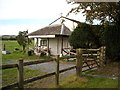
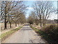
Chiseldon Cricket Club, Draycot Foliat
The clubhouse of Chiseldon Cricket Club, Draycot Foliat. Judging from the lumpy state of the turf, the cricket pitch has not been used for some time.
Image: © Vieve Forward
Taken: 5 Oct 2014
0.08 miles
4
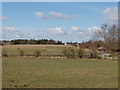
Sheppards Farm, Draycot Foliat
View from road to the east.
Image: © David Hawgood
Taken: 6 Mar 2006
0.11 miles
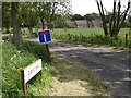
5
Quebec Road, Draycot Foliat
Part of Chisledon Camp from 1914 to about 1958. In 1916 Chisledon became the headquarters of the Army Cyclists Corps, with the Australian and Canadian Cycling Corps also training there.
Image: © David Hawgood
Taken: 6 Mar 2006
0.11 miles
6
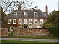
Draycot Farmhouse, Draycot Foliat
Grade II Listed early 18th century farmhouse http://www.britishlistedbuildings.co.uk/en-318301-draycot-farmhouse-chiseldon- consisting of two storeys with red and blue brick facing and seven bays. It has a hipped slate roof and two brick chimneys. The central portico has Tuscan columns, a moulded cornice and a broken segmental pediment with vase (according to the listing text, the portico appears to be a later insertion). The front boundary walls and garden pavilion are also listed. http://www.britishlistedbuildings.co.uk/en-318302-boundary-walls-to-front-and-garden-pavil The corner pavilion to south-west has a Victorian letter box, see Image] and Image
Image: © Vieve Forward
Taken: 5 Oct 2014
0.17 miles
7
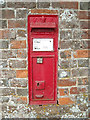
Victorian letterbox, Draycot Foliat
Victorian letterbox in the wall of the Grade II Listed garden pavilion to Draycot Farmhouse Image http://www.britishlistedbuildings.co.uk/en-318302-boundary-walls-to-front-and-garden-pavil See also Image
Image: © Vieve Forward
Taken: 5 Oct 2014
0.18 miles
8
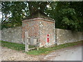
Corner pavilion with Victorian letterbox, Draycot Farmhouse, Draycot Foliat
Grade II Listed corner pavilion to Draycot Farmhouse Image http://www.britishlistedbuildings.co.uk/en-318302-boundary-walls-to-front-and-garden-pavil Built of red and blue brick with a pyramidal hipped stone tile roof, it has a Victorian letter box inserted in the side, see also Image The front boundary wall which continues from the pavilion is also listed.
Image: © Vieve Forward
Taken: 5 Oct 2014
0.18 miles
9
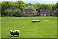
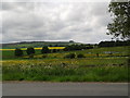
Pasture, Chiseldon
Houses on Talavera Road are some of those built on the site of a former military base.
Image: © Andrew Smith
Taken: 7 May 2023
0.19 miles
10
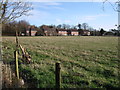
Talavera Road from Quebec Road
These roads and houses were formerly part of Chiseldon Camp http://www.chiseldonlhg.org.uk/Camp.htm whose military purpose was reflected in the names.
Image: © Vieve Forward
Taken: 29 Nov 2012
0.20 miles