IMAGES TAKEN NEAR TO
Manor Rise, SWINDON, SN4 0FU
Introduction
This page details the photographs taken nearby to Manor Rise, SN4 0FU by members of the Geograph project.
The Geograph project started in 2005 with the aim of publishing, organising and preserving representative images for every square kilometre of Great Britain, Ireland and the Isle of Man.

There are currently over 7.5m images from over14,400 individuals and you can help contribute to the project by visiting https://www.geograph.org.uk
Image Map
Images are licensed for reuse under creativecommons.org/licenses/by-sa/2.0
Notes
- Clicking on the map will re-center to the selected point.
- The higher the marker number, the further away the image location is from the centre of the postcode.
Image Listing (100 Images Found)
Images are licensed for reuse under creativecommons.org/licenses/by-sa/2.0
Image
Details
Distance
1
![Chiseldon buildings [8]](https://s0.geograph.org.uk/geophotos/06/42/77/6427780_1f018d6a_120x120.jpg)
Chiseldon buildings [8]
This fine Primitive Methodist chapel was constructed in 1896. The chapel was sold in 2006 and converted to residential use.
Chiseldon village was founded by the Saxons and lies 3 miles south of Swindon on the Roman road from Cirencester and Mildenhall, now the A346. An agricultural village until the late 19th century but now most workers commute to Swindon. In 1914 a large military camp was built south of the village with the camp population being greater than that of the village. The military presence continued until 1961.
Image: © Michael Dibb
Taken: 11 Mar 2020
0.04 miles
2
![Chiseldon houses [19]](https://s2.geograph.org.uk/geophotos/06/42/77/6427782_b29dd9af_120x120.jpg)
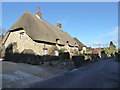
Chiseldon houses [19]
Thatched roofed number 20 Turnball has its gable end to the road.
Chiseldon village was founded by the Saxons and lies 3 miles south of Swindon on the Roman road from Cirencester and Mildenhall, now the A346. An agricultural village until the late 19th century but now most workers commute to Swindon. In 1914 a large military camp was built south of the village with the camp population being greater than that of the village. The military presence continued until 1961.
Image: © Michael Dibb
Taken: 11 Mar 2020
0.07 miles
3
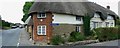
![Chiseldon houses [20]](https://s0.geograph.org.uk/geophotos/06/42/77/6427784_9768d8b8_120x120.jpg)
Chiseldon houses [20]
This 17th or early 18th century thatched building was originally three cottages, now two. Listed, grade II, with details at: https://historicengland.org.uk/listing/the-list/list-entry/1023329
Chiseldon village was founded by the Saxons and lies 3 miles south of Swindon on the Roman road from Cirencester and Mildenhall, now the A346. An agricultural village until the late 19th century but now most workers commute to Swindon. In 1914 a large military camp was built south of the village with the camp population being greater than that of the village. The military presence continued until 1961.
Image: © Michael Dibb
Taken: 11 Mar 2020
0.07 miles
6
![Chiseldon houses [18]](https://s3.geograph.org.uk/geophotos/06/42/77/6427779_ed46eb65_120x120.jpg)
Chiseldon houses [18]
Number 3 Turnball is 18th century with early 19th century alterations and a mid 19th century extension. Listed, grade II, with details at: https://historicengland.org.uk/listing/the-list/list-entry/1184481
Chiseldon village was founded by the Saxons and lies 3 miles south of Swindon on the Roman road from Cirencester and Mildenhall, now the A346. An agricultural village until the late 19th century but now most workers commute to Swindon. In 1914 a large military camp was built south of the village with the camp population being greater than that of the village. The military presence continued until 1961.
Image: © Michael Dibb
Taken: 11 Mar 2020
0.09 miles
7
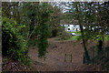
Site of Chiseldon railway station,Chiseldon, Swindon
Chiseldon was on the old Midland and South Western Junction railway that in its heyday ran from Cheltenham to Andover with its head office in Swindon. The line closed in 1961 having been judged to have outlived its usefulness. Somehow the site has escaped the attentions of developers.
Image: © Brian Robert Marshall
Taken: 3 Nov 2007
0.09 miles
8
Stroud's Hill, Chiseldon
This is the site of the old station.
Image: © Robert Eva
Taken: 6 Dec 2017
0.10 miles
9

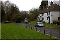
Old Toll House by Turnball, Chiseldon
Turnball Toll House by the B4005, in parish of Chiseldon (Swindon District), No. 27, Turnball at junction with Hodson Road, SN4.
Grade II listed.
List Entry Number: 1355979 https://historicengland.org.uk/listing/the-list/list-entry/1355979
Surveyed
Milestone Society National ID: WI.CHS02
Image: © Alan Rosevear
Taken: 7 Mar 2005
0.10 miles
10
27 Turnball, Chiseldon (2)
This is another view of the former toll house seen here http://www.geograph.org.uk/photo/1945891 Hodson Road leads away from the viewpoint at the left.
Image: © Brian Robert Marshall
Taken: 30 Jun 2010
0.10 miles