IMAGES TAKEN NEAR TO
Lucknam Crescent, SWINDON, SN3 6FW
Introduction
This page details the photographs taken nearby to Lucknam Crescent, SN3 6FW by members of the Geograph project.
The Geograph project started in 2005 with the aim of publishing, organising and preserving representative images for every square kilometre of Great Britain, Ireland and the Isle of Man.

There are currently over 7.5m images from over14,400 individuals and you can help contribute to the project by visiting https://www.geograph.org.uk
Image Map
Images are licensed for reuse under creativecommons.org/licenses/by-sa/2.0
Notes
- Clicking on the map will re-center to the selected point.
- The higher the marker number, the further away the image location is from the centre of the postcode.
Image Listing (14 Images Found)
Images are licensed for reuse under creativecommons.org/licenses/by-sa/2.0
Image
Details
Distance
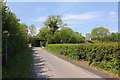
1
Just another road
It may not look much but this is part of an old Roman road that once was a strategic part of the highway network of the UK. It lies immediately adjacent to the A419 dual carriageway south of Commonhead, Swindon.
Image: © Brian Robert Marshall
Taken: 13 Jan 2007
0.07 miles
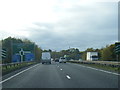
3
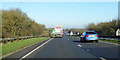
Northbound A419, Swindon
The junction for the A4259 into town is ahead.
Image: © Robin Webster
Taken: 19 Jan 2020
0.09 miles
4
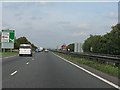
A419 - the southernmost section
Viewed from just north of the M4 roundabout, the start of what is now - with one glaring exception around Birdlip Hill - an first-class "A" road across country from Swindon to Gloucester. One of the rare UK examples of transport investment in the right place.
Image: © J Whatley
Taken: 22 Sep 2010
0.10 miles
5
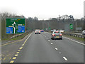
Southbound A419, Approaching the Junction with the M4
Image: © David Dixon
Taken: 1 Apr 2013
0.13 miles
6
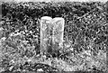
Old Milestone by the A419, Marlborough Road, Chiseldon
Swindon thin D stone by the A419, in parish of Chiseldon (Swindon District), roadside, by the West side of road.
Lost since 1990.
The inscription appears to read:-
: TO / (Marlborough) / 8 : : TO / SWINDON / 3 :
(Which agrees with Old-maps)
Milestone Society National ID: WI_MLSN08
Image: © Milestone Society
Taken: Unknown
0.14 miles
7
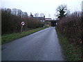
House next to A419(T) road bridge, Badbury
House situated next to road bridge carrying dual carriageway to M4 interchange no.15. The house was for sale when this photograph was taken.
Image: © Vieve Forward
Taken: 2 Jan 2013
0.16 miles
8

A419 north of the M4
Half a mile to the exit for Swindon and the new hospital.
Image: © Julian P Guffogg
Taken: 7 Aug 2013
0.16 miles