IMAGES TAKEN NEAR TO
Coatley Close, SWINDON, SN3 6FL
Introduction
This page details the photographs taken nearby to Coatley Close, SN3 6FL by members of the Geograph project.
The Geograph project started in 2005 with the aim of publishing, organising and preserving representative images for every square kilometre of Great Britain, Ireland and the Isle of Man.

There are currently over 7.5m images from over14,400 individuals and you can help contribute to the project by visiting https://www.geograph.org.uk
Image Map
Images are licensed for reuse under creativecommons.org/licenses/by-sa/2.0
Notes
- Clicking on the map will re-center to the selected point.
- The higher the marker number, the further away the image location is from the centre of the postcode.
Image Listing (11 Images Found)
Images are licensed for reuse under creativecommons.org/licenses/by-sa/2.0
Image
Details
Distance
1
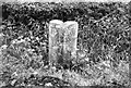
Old Milestone by the A419, Marlborough Road, Chiseldon
Swindon thin D stone by the A419, in parish of Chiseldon (Swindon District), roadside, by the West side of road.
Lost since 1990.
The inscription appears to read:-
: TO / (Marlborough) / 8 : : TO / SWINDON / 3 :
(Which agrees with Old-maps)
Milestone Society National ID: WI_MLSN08
Image: © Milestone Society
Taken: Unknown
0.05 miles
2
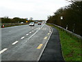
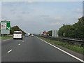
A419 looking north to Commonhead, Swindon
The A419 is undergoing improvements just over a kilometre north of the layby. This is to remove a bottleneck at Commonhead. Work is on schedule for completion in the spring of 2007.
Image: © Brian Robert Marshall
Taken: 13 Jan 2007
0.05 miles
3
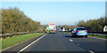
Northbound A419, Swindon
The junction for the A4259 into town is ahead.
Image: © Robin Webster
Taken: 19 Jan 2020
0.10 miles
4
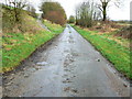
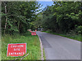
Just another road
It may not look much but this is part of an old Roman road that once was a strategic part of the highway network of the UK. It lies immediately adjacent to the A419 dual carriageway south of Commonhead, Swindon.
Image: © Brian Robert Marshall
Taken: 13 Jan 2007
0.14 miles
5
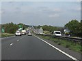
A419 - the southernmost section
Viewed from just north of the M4 roundabout, the start of what is now - with one glaring exception around Birdlip Hill - an first-class "A" road across country from Swindon to Gloucester. One of the rare UK examples of transport investment in the right place.
Image: © J Whatley
Taken: 22 Sep 2010
0.19 miles
6

A419 looking north towards Common Head, Swindon
The image was obtained the day before the flyover visible in the distance opened for traffic.
Image: © Brian Robert Marshall
Taken: 4 Feb 2007
0.21 miles
8
A419 approaching Commonhead junction
The A419/ A417 has been steadily improved since the 1980s, gradually being transformed into a truly excellent road (albeit with a huge exception at Birdlip Hill in Gloucestershire). The most recent schemes (2007-9) have eliminated residual traffic light and roundabout junctions around Swindon with bypasses and motorway-style junctions. Commonhead is one of the latter. Transport investment in the right place for once. For a "works phase" photo from a similar position, see: http://www.geograph.org.uk/photo/432399
Image: © J Whatley
Taken: 22 Sep 2010
0.23 miles
9
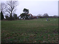
Thatched cottage, Badbury Wick
Thatched farm cottage, Badbury Wick. The Great Western Hospital can be seen in the distance behind it.
Image: © Vieve Forward
Taken: 2 Jan 2013
0.23 miles
10
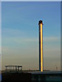
Chimney, energy centre, Great Western Hospital, Swindon
The stack can be seen in this image Image The mast just visible on the centre skyline is at Foxhill (SU234813) 4.4 km away.
Image: © Brian Robert Marshall
Taken: 4 Feb 2007
0.23 miles