IMAGES TAKEN NEAR TO
Firecrest View, SWINDON, SN3 5LS
Introduction
This page details the photographs taken nearby to Firecrest View, SN3 5LS by members of the Geograph project.
The Geograph project started in 2005 with the aim of publishing, organising and preserving representative images for every square kilometre of Great Britain, Ireland and the Isle of Man.

There are currently over 7.5m images from over14,400 individuals and you can help contribute to the project by visiting https://www.geograph.org.uk
Image Map (Loading...)


Getting Data...Please wait
Leaflet Map data © OpenStreetMap
Images are licensed for reuse under creativecommons.org/licenses/by-sa/2.0
Notes
- Clicking on the map will re-center to the selected point.
- The higher the marker number, the further away the image location is from the centre of the postcode.
Image Listing (13 Images Found)
Images are licensed for reuse under creativecommons.org/licenses/by-sa/2.0
Image
Details
Distance
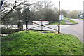
1
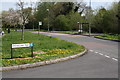
Junction of Pinnegar Way and St Paul's Drive
There was a bus stop shelter which had an Ordnance Survey benchmark ( http://www.bench-marks.org.uk/bm56146 ) on the left hand side of St Paul's Drive where just a concrete base and bus stop sign remain
Image: © Roger Templeman
Taken: 17 Apr 2015
0.06 miles
2
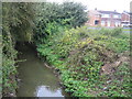
Dorcan Stream in Covingham, Swindon
Viewed looking upstream from the Bullfinch Close road bridge with the houses in Gilling Way visible to the right.
Image: © Nigel Cox
Taken: 12 Oct 2007
0.11 miles
3
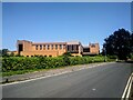
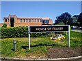
The Fraser Centre, Faraday Road, Swindon
Permission has been granted for this building to be demolished. The Fraser Centre once provided data and IT support for the department store group House of Fraser. It has been in decline since 2010 when the IT function was outsourced. It finally became empty in 2020. A property company has been granted planning permission to demolish the building in advance of the erection of seven General industrial (use class B2)/ Storage or distribution (use class B8)/ Commercial, business and service (use class E) units successfully arguing that no future use for the existing building could be identified.
Image: © Brian Robert Marshall
Taken: 14 Jun 2023
0.16 miles
4
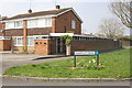
House Of Fraser Information Systems, Faraday Road, Swindon
The IT people for the well-known department store chain work here. The road names here include Wheatstone, Edison and Murdock - pioneers in the world of physics.
Image: © Brian Robert Marshall
Taken: 1 Jan 2007
0.16 miles
5
The Fraser Centre, Faraday Road, Swindon
Permission has been granted for this building to be demolished. The Fraser Centre once provided data and IT support for the department store group House of Fraser. It has been in decline since 2010 when the IT function was outsourced. It finally became empty in 2020. A property company has been granted planning permission to demolish the building in advance of the erection of seven General industrial (use class B2)/ Storage or distribution (use class B8)/ Commercial, business and service (use class E) units successfully arguing that no future use for the existing building could be identified.
Image: © Brian Robert Marshall
Taken: 14 Jun 2023
0.17 miles
6
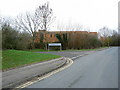
Junction of Gantlettdene and St Paul's Drive
There is an OS benchmark Image on the garage wall, above the pavement of St Paul's Drive (at the junction of the garage and car port walls)
Image: © Roger Templeman
Taken: 9 Apr 2015
0.17 miles
7
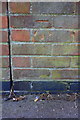
Benchmark on bridge pier at entrance to The Dorcan Academy
Ordnance Survey cut mark benchmark described on the Bench Mark Database at http://www.bench-marks.org.uk/bm56147
Image: © Roger Templeman
Taken: 9 Apr 2015
0.18 miles
8
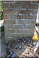
Benchmark on St Paul's Drive wall
Ordnance Survey cut mark benchmark described on the Bench Mark Database at http://www.bench-marks.org.uk/bm56145
Image: © Roger Templeman
Taken: 9 Apr 2015
0.18 miles
9
Bridge over Dorcan Stream from St Paul's Drive
There is an OS benchmark Image on the bridge pier left of the centre of the image
Image: © Roger Templeman
Taken: 9 Apr 2015
0.18 miles
10
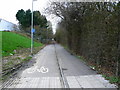
Cycle track/footpath from Faraday Road to Dorcan Way, Swindon
The cycle track terminates in the distance at SU186843 over 500 metres from the viewing point.
Image: © Brian Robert Marshall
Taken: 1 Jan 2007
0.22 miles