IMAGES TAKEN NEAR TO
Faraday Park, Faraday Road, SWINDON, SN3 5JF
Introduction
This page details the photographs taken nearby to Faraday Park, Faraday Road, SN3 5JF by members of the Geograph project.
The Geograph project started in 2005 with the aim of publishing, organising and preserving representative images for every square kilometre of Great Britain, Ireland and the Isle of Man.

There are currently over 7.5m images from over14,400 individuals and you can help contribute to the project by visiting https://www.geograph.org.uk
Image Map
Images are licensed for reuse under creativecommons.org/licenses/by-sa/2.0
Notes
- Clicking on the map will re-center to the selected point.
- The higher the marker number, the further away the image location is from the centre of the postcode.
Image Listing (20 Images Found)
Images are licensed for reuse under creativecommons.org/licenses/by-sa/2.0
Image
Details
Distance
1
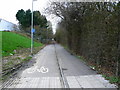
Cycle track/footpath from Faraday Road to Dorcan Way, Swindon
The cycle track terminates in the distance at SU186843 over 500 metres from the viewing point.
Image: © Brian Robert Marshall
Taken: 1 Jan 2007
0.10 miles
2

The Fraser Centre, Faraday Road, Swindon
Permission has been granted for this building to be demolished. The Fraser Centre once provided data and IT support for the department store group House of Fraser. It has been in decline since 2010 when the IT function was outsourced. It finally became empty in 2020. A property company has been granted planning permission to demolish the building in advance of the erection of seven General industrial (use class B2)/ Storage or distribution (use class B8)/ Commercial, business and service (use class E) units successfully arguing that no future use for the existing building could be identified.
Image: © Brian Robert Marshall
Taken: 14 Jun 2023
0.10 miles
3
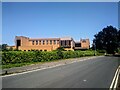
The Fraser Centre, Faraday Road, Swindon
Permission has been granted for this building to be demolished. The Fraser Centre once provided data and IT support for the department store group House of Fraser. It has been in decline since 2010 when the IT function was outsourced. It finally became empty in 2020. A property company has been granted planning permission to demolish the building in advance of the erection of seven General industrial (use class B2)/ Storage or distribution (use class B8)/ Commercial, business and service (use class E) units successfully arguing that no future use for the existing building could be identified.
Image: © Brian Robert Marshall
Taken: 14 Jun 2023
0.11 miles
4
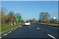
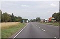
Northbound A419
Bypassing Swindon to the east.
Image: © Robin Webster
Taken: 9 Jan 2022
0.12 miles
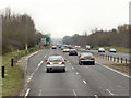
6
Approaching Parking Area on A419
East of Swindon.
Image: © Julian P Guffogg
Taken: 7 Aug 2013
0.12 miles

8
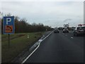
Lay-by beside A419 at Dorcan
There is a substantial drainage ditch beside the A419 here
Image: © David Smith
Taken: 28 Dec 2011
0.13 miles
9
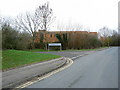
House Of Fraser Information Systems, Faraday Road, Swindon
The IT people for the well-known department store chain work here. The road names here include Wheatstone, Edison and Murdock - pioneers in the world of physics.
Image: © Brian Robert Marshall
Taken: 1 Jan 2007
0.13 miles
10
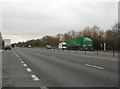
Looking south along the A419
At Dorcan, part of Swindon Borough Council in Wiltshire.
Image: © James Denham
Taken: 12 Jan 2012
0.13 miles