IMAGES TAKEN NEAR TO
Foxbridge, SWINDON, SN3 5BW
Introduction
This page details the photographs taken nearby to Foxbridge, SN3 5BW by members of the Geograph project.
The Geograph project started in 2005 with the aim of publishing, organising and preserving representative images for every square kilometre of Great Britain, Ireland and the Isle of Man.

There are currently over 7.5m images from over14,400 individuals and you can help contribute to the project by visiting https://www.geograph.org.uk
Image Map (Loading...)


Getting Data...Please wait
Leaflet Map data © OpenStreetMap
Images are licensed for reuse under creativecommons.org/licenses/by-sa/2.0
Notes
- Clicking on the map will re-center to the selected point.
- The higher the marker number, the further away the image location is from the centre of the postcode.
Image Listing (19 Images Found)
Images are licensed for reuse under creativecommons.org/licenses/by-sa/2.0
Image
Details
Distance
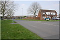
1
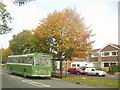
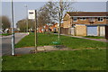
Autumn at Covingham Park
A bus stop on Kingfisher Drive at Covingham Park, as the trees begin to change colour in autumn. Many of the streets in this area have the names of birds. The Bristol RE bus is giving free trips around Swindon today.
Image: © David Roberts
Taken: Unknown
0.03 miles
2
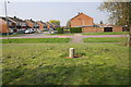
Junction of Kingfisher Drive and Foxbridge
There is an OS benchmark Image on the far end of the garage of the near house at the junction with a wooden fence
Image: © Roger Templeman
Taken: 9 Apr 2015
0.05 miles
3
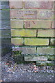
Benchmark on Kingfisher Drive wall
Ordnance Survey cut mark benchmark described on the Bench Mark Database at http://www.bench-marks.org.uk/bm56143
Image: © Roger Templeman
Taken: 9 Apr 2015
0.05 miles
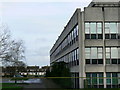
4
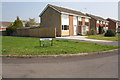
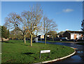
Robinsgreen from Kingfisher Drive
This whole area is densely populated but there are a lot of lawns and trees as well as houses, which gives it a more open feeling than in a lot of suburban developments.
Image: © Des Blenkinsopp
Taken: 9 Nov 2022
0.07 miles
5
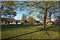
Corner of Dovetrees
Another view of the grassy verges and roadside trees which are part of the appearance of this neighbourhood.
Image: © Des Blenkinsopp
Taken: 9 Nov 2022
0.09 miles
6
Junction of Kingfisher Drive and Martinfield
Maps of the 1970s show a subway under Kingfisher Drive here, but there is no sign of it now. See http://www.bench-marks.org.uk/bm56142
Image: © Roger Templeman
Taken: 9 Apr 2015
0.11 miles
7
Bus stop on St Paul's Drive
There used to be a bus shelter here: now just the concrete base remains with a seat on it. See http://www.bench-marks.org.uk/bm56148
Image: © Roger Templeman
Taken: 9 Apr 2015
0.16 miles
8
St Paul's Drive, Covingham
Another of the spacious, tree lined roads in this area.
Image: © Des Blenkinsopp
Taken: 9 Nov 2022
0.16 miles
9
Junction of St Paul's Drive and Cornmarsh Way
The tarmac patch on the left hand side verge by the bus stop sign is possibly the site of a bus shelter which had an Ordnance Survey benchmark, http://www.bench-marks.org.uk/bm56144
Image: © Roger Templeman
Taken: 9 Apr 2015
0.16 miles
10
Houses in St Pauls Drive, Covingham, Swindon
The large building at right of the image is a drug manufacturer called Patheon UK Ltd. It and the houses went up in the 1960s.
Image: © Brian Robert Marshall
Taken: 7 Jan 2007
0.18 miles