IMAGES TAKEN NEAR TO
Ermin Street, SWINDON, SN3 4RQ
Introduction
This page details the photographs taken nearby to Ermin Street, SN3 4RQ by members of the Geograph project.
The Geograph project started in 2005 with the aim of publishing, organising and preserving representative images for every square kilometre of Great Britain, Ireland and the Isle of Man.

There are currently over 7.5m images from over14,400 individuals and you can help contribute to the project by visiting https://www.geograph.org.uk
Image Map
Images are licensed for reuse under creativecommons.org/licenses/by-sa/2.0
Notes
- Clicking on the map will re-center to the selected point.
- The higher the marker number, the further away the image location is from the centre of the postcode.
Image Listing (30 Images Found)
Images are licensed for reuse under creativecommons.org/licenses/by-sa/2.0
Image
Details
Distance
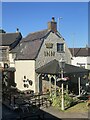
1
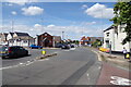
Houses on Ermin Street, Stratton St Margaret
Image: © David Howard
Taken: 9 Sep 2018
0.06 miles
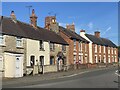
2
Ermin Street in Stratton St Margaret
Ermin Street follows a former Roman Road.
Image: © Steve Daniels
Taken: 9 Mar 2014
0.11 miles
4
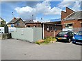
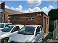
Disused public conveniences, Highworth Road, Stratton, Swindon (1)
In view is a small Council-owned building housing long-disused public conveniences. The conveniences are due to be demolished in the near future, so, unloved and unwanted as they seem to be, they will soon be forgotten. It is only right that this modest building should be memorialised in some way so this photo and a couple of others will suffice for that purpose.
Acknowledgements to the Crown public house and restaurant for providing the viewpoint.
Image: © Brian Robert Marshall
Taken: 12 Jul 2019
0.12 miles
5
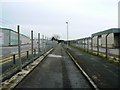
Footpath and cycle track, Parsonage Road, Swindon
This right of way connects an unnamed road behind the viewpoint to Parsonage Road proper up ahead. Either side are industrial/commercial areas. The one to the left is called Europa Industrial Park and contains a mix of logistics and manufacturing businesses. Parsonage Road eventually connects with Ermin Street, the old Roman road, which, although by-passed now, is still busy with intra-urban traffic. This image was obtained on New Year's Day, which explains why it all looks rather deserted.
Image: © Brian Robert Marshall
Taken: 1 Jan 2007
0.12 miles
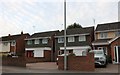
6
St Margaret's garage and disused public conveniences, Highworth Road, Stratton, Swindon
At the right is a small Council-owned building housing long-disused public conveniences. The conveniences are due to be demolished in the near future, so, unloved and unwanted as they seem to be, they will soon be forgotten. It is only right that this modest building should be memorialised in some way so this photo and a couple of others will suffice for that purpose.
The adjacent garage seems also to be unused but isn't owned by the Council so might well remain for the time being.
Image: © Brian Robert Marshall
Taken: 12 Jul 2019
0.12 miles
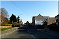
7
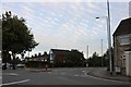
Roundabout on Ermin Street, Stratton St Margaret
For reasons only known to Swindon council the road is closed here and traffic diverted round a very long block if they wish to continue on Ermin Street. Only buses are now allowed to use it as it was before.
Image: © David Howard
Taken: 9 Sep 2018
0.13 miles
8
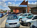
B4006 Hobley Drive, Stratton St. Margaret
At the junction with Ermin Street, B4006 Highworth Road & B4006 Ermin Street
Image: © Geographer
Taken: 14 Jul 2022
0.13 miles
9
Disused public conveniences, Highworth Road, Stratton, Swindon (2)
In view is a small Council-owned building housing long-disused public conveniences. The conveniences are due to be demolished in the near future, so, unloved and unwanted as they seem to be, they will soon be forgotten. It is only right that this modest building should be memorialised in some way so this photo and a couple of others will suffice for that purpose.
Image: © Brian Robert Marshall
Taken: 12 Jul 2019
0.13 miles