IMAGES TAKEN NEAR TO
John Herring Crescent, SWINDON, SN3 4JJ
Introduction
This page details the photographs taken nearby to John Herring Crescent, SN3 4JJ by members of the Geograph project.
The Geograph project started in 2005 with the aim of publishing, organising and preserving representative images for every square kilometre of Great Britain, Ireland and the Isle of Man.

There are currently over 7.5m images from over14,400 individuals and you can help contribute to the project by visiting https://www.geograph.org.uk
Image Map (Loading...)


Getting Data...Please wait
Leaflet Map data © OpenStreetMap
Images are licensed for reuse under creativecommons.org/licenses/by-sa/2.0
Notes
- Clicking on the map will re-center to the selected point.
- The higher the marker number, the further away the image location is from the centre of the postcode.
Image Listing (14 Images Found)
Images are licensed for reuse under creativecommons.org/licenses/by-sa/2.0
Image
Details
Distance
1
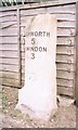
Old Milestone by the B4006, Swindon Road, Lower Stratton
Swindon half-round stone by the B4006, in parish of Stratton St Margaret (Swindon District), Lower Stratton, outside No. 161 Swindon Road, in front of fence, behind tarmac footpath.
Inscription reads:-
HIGHWORTH
5
SWINDON
3
Carved benchmark on face.
Surveyed
Milestone Society National ID: WI_SNLC02
Image: © Milestone Society
Taken: Unknown
0.10 miles
2

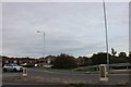
Swindon : Road Sign
A road sign giving directions to parts of Swindon
Image: © Lewis Clarke
Taken: 22 Oct 2008
0.13 miles
5
The Dockle Farmhouse by Greenbridge
The Dockle Farmhouse is a Wetherspoon pub.
Image: © Steve Daniels
Taken: 27 Oct 2013
0.19 miles
6
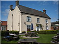
The Dockle Farmhouse
The original farmhouse is part of a Wetherspoon pub of the same name.
Image: © Vieve Forward
Taken: 12 Apr 2017
0.19 miles
7
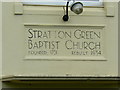
Stratton Green Baptist Church, Swindon Road, Stratton, Swindon
The plaque above the door shows its 1930s origins in the typography.
Image: © Brian Robert Marshall
Taken: 13 Jun 2007
0.20 miles
9
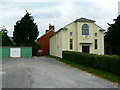
Stratton Green Baptist Church, Swindon Road, Stratton, Swindon
Here since 1751 (in its present form since 1934). A well maintained building. Just visible between the trees on the left is the BMW MINI body plant.
Image: © Brian Robert Marshall
Taken: 13 Jun 2007
0.20 miles
10
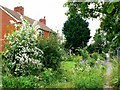
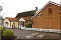
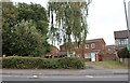
Cottages, Swindon Road, Stratton, Swindon
The parish of Stratton St Margaret is a large parish containing cottages much older than these Victorian examples and large industrial plants such as the BMW MINI body plant. If you turn through just over 90 degrees from the viewpoint in this image you will see this... http://www.geograph.org.uk/photo/465579
Image: © Brian Robert Marshall
Taken: 13 Jun 2007
0.20 miles