IMAGES TAKEN NEAR TO
Oxford Road, SWINDON, SN3 4HA
Introduction
This page details the photographs taken nearby to Oxford Road, SN3 4HA by members of the Geograph project.
The Geograph project started in 2005 with the aim of publishing, organising and preserving representative images for every square kilometre of Great Britain, Ireland and the Isle of Man.

There are currently over 7.5m images from over14,400 individuals and you can help contribute to the project by visiting https://www.geograph.org.uk
Image Map
Images are licensed for reuse under creativecommons.org/licenses/by-sa/2.0
Notes
- Clicking on the map will re-center to the selected point.
- The higher the marker number, the further away the image location is from the centre of the postcode.
Image Listing (17 Images Found)
Images are licensed for reuse under creativecommons.org/licenses/by-sa/2.0
Image
Details
Distance
4
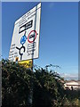
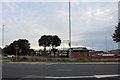
Swindon : Road Sign
A road sign giving directions to parts of Swindon
Image: © Lewis Clarke
Taken: 22 Oct 2008
0.17 miles
5
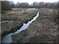
River Cole, near Greenbridge
The River Cole emerges from the bowels of Swindon not far from here and runs through this scruffy patch of wilderness out of sight of the nearby Greenbridge Trading Estate, the WHSmith headquarters, and the Covingham housing estate. It flows out of Swindon and via Coleshill to join the Thames just below Lechlade.
Image: © Vieve Forward
Taken: 22 Mar 2013
0.18 miles
8
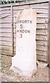
Old Milestone by the B4006, Swindon Road, Lower Stratton
Swindon half-round stone by the B4006, in parish of Stratton St Margaret (Swindon District), Lower Stratton, outside No. 161 Swindon Road, in front of fence, behind tarmac footpath.
Inscription reads:-
HIGHWORTH
5
SWINDON
3
Carved benchmark on face.
Surveyed
Milestone Society National ID: WI_SNLC02
Image: © Milestone Society
Taken: Unknown
0.21 miles
9
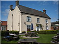
The Dockle Farmhouse
The original farmhouse is part of a Wetherspoon pub of the same name.
Image: © Vieve Forward
Taken: 12 Apr 2017
0.22 miles