IMAGES TAKEN NEAR TO
Keyneston Road, SWINDON, SN3 3PT
Introduction
This page details the photographs taken nearby to Keyneston Road, SN3 3PT by members of the Geograph project.
The Geograph project started in 2005 with the aim of publishing, organising and preserving representative images for every square kilometre of Great Britain, Ireland and the Isle of Man.

There are currently over 7.5m images from over14,400 individuals and you can help contribute to the project by visiting https://www.geograph.org.uk
Image Map
Images are licensed for reuse under creativecommons.org/licenses/by-sa/2.0
Notes
- Clicking on the map will re-center to the selected point.
- The higher the marker number, the further away the image location is from the centre of the postcode.
Image Listing (15 Images Found)
Images are licensed for reuse under creativecommons.org/licenses/by-sa/2.0
Image
Details
Distance
1
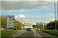
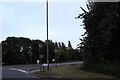
Dorcan Way approaching Kingfisher roundabout
Image: © Steve Daniels
Taken: 30 Apr 2015
0.09 miles
2
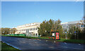
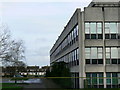
Dorcan Way, Swindon
Dorcan Way, B4006, is the major road through a large area of suburbs on the west side of Swindon.
The large building is Patheon Pharma Services.
Image: © Des Blenkinsopp
Taken: 9 Nov 2022
0.09 miles
3
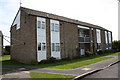
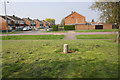
#21-26 Fieldfare, sheltered housing
There was an Ordnance Survey benchmark (see http://www.bench-marks.org.uk/bm56141 ) on the far end of the block, but this face has been rendered
Image: © Roger Templeman
Taken: 17 Apr 2015
0.09 miles
4
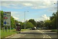
Dorcan Way approaching The Drive roundabout
Image: © Steve Daniels
Taken: 30 Apr 2015
0.09 miles
5
Dorcan Way at the junction of The Drive
Image: © David Howard
Taken: 9 Sep 2018
0.11 miles
6
Houses in St Pauls Drive, Covingham, Swindon
The large building at right of the image is a drug manufacturer called Patheon UK Ltd. It and the houses went up in the 1960s.
Image: © Brian Robert Marshall
Taken: 7 Jan 2007
0.13 miles
7
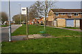
Bus stop on St Paul's Drive
There used to be a bus shelter here: now just the concrete base remains with a seat on it. See http://www.bench-marks.org.uk/bm56148
Image: © Roger Templeman
Taken: 9 Apr 2015
0.14 miles
8
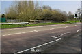
Bridge for Dorcan Way (B4006) over Dorcan Stream
Image: © Roger Templeman
Taken: 9 Apr 2015
0.15 miles
9
Junction of Kingfisher Drive and Martinfield
Maps of the 1970s show a subway under Kingfisher Drive here, but there is no sign of it now. See http://www.bench-marks.org.uk/bm56142
Image: © Roger Templeman
Taken: 9 Apr 2015
0.18 miles
10
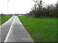
Footpath/cycletrack from Dorcan Way to Eldene Drive, Swindon
The houses in the background are on the northern edge of Eldene, Swindon.
Image: © Brian Robert Marshall
Taken: 7 Jan 2007
0.21 miles