IMAGES TAKEN NEAR TO
Queens Drive, SWINDON, SN3 1AR
Introduction
This page details the photographs taken nearby to Queens Drive, SN3 1AR by members of the Geograph project.
The Geograph project started in 2005 with the aim of publishing, organising and preserving representative images for every square kilometre of Great Britain, Ireland and the Isle of Man.

There are currently over 7.5m images from over14,400 individuals and you can help contribute to the project by visiting https://www.geograph.org.uk
Image Map
Images are licensed for reuse under creativecommons.org/licenses/by-sa/2.0
Notes
- Clicking on the map will re-center to the selected point.
- The higher the marker number, the further away the image location is from the centre of the postcode.
Image Listing (100 Images Found)
Images are licensed for reuse under creativecommons.org/licenses/by-sa/2.0
Image
Details
Distance
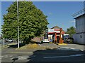
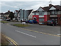
1
Ambulance station, Queen's Drive, Swindon
Near the famous 'Magic Roundabout'.
Image: © Stephen Craven
Taken: 14 Jul 2022
0.01 miles
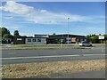
3
Burger King Drive-Thru, Queen's Drive, Swindon
Near the famous 'Magic Roundabout'.
Image: © Stephen Craven
Taken: 14 Jul 2022
0.06 miles
4
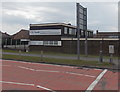
A.E.Smith & Son, Swindon
This is the Queen's Drive (A4259) side of the funeral directors and
monumental stonemasons premises. The main entrance is from Dudmore Road.
Image: © Jaggery
Taken: 14 Apr 2013
0.07 miles
5

Burger King Drive-Thru, Queens Drive, Swindon
The houses to the left are in Munro Close. The top of the taller building on the skyline at left of the signage is the DMJ Building. Image
Image: © Brian Robert Marshall
Taken: 7 Jan 2007
0.08 miles
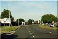
6
Dudmore Road, Swindon
Looking east from the Drove Road end.
Image: © Jaggery
Taken: 14 Apr 2013
0.08 miles
7
A E Smith and Son, Funeral Directors, Queens Drive, Swindon
Although the postal address of this long-established firm is as in the title, the actual entrance is from Dudmore Road, visible in the foreground. The firm began operating in Swindon in the 1880s nearer the centre of the town and moved to this location in the 1960s.
Image: © Brian Robert Marshall
Taken: 26 Feb 2010
0.08 miles
8
Substation on Burford Avenue
Unusually, with plant not protected within a building.
Image: © Stephen Craven
Taken: 14 Jul 2022
0.09 miles
9
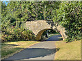
Route of Wilts and Berks Canal
Route of the former Wilts and Berks Canal, now a footpath linking Queen's Drive and Ocotal Way. The bridge is a former footpath bridge over the canal, dating from c.1810 and is grade II listed - see https://historicengland.org.uk/listing/the-list/list-entry/1355880?section=official-list-entry.
Image: © Ian Capper
Taken: 14 Jul 2022
0.09 miles
10
Shrivenham Road, Swindon
Shrivenham Road heads NE away from the Magic Roundabout.
Image: © Jaggery
Taken: 14 Apr 2013
0.09 miles