IMAGES TAKEN NEAR TO
Blunsdon, SWINDON, SN26 7ER
Introduction
This page details the photographs taken nearby to SN26 7ER by members of the Geograph project.
The Geograph project started in 2005 with the aim of publishing, organising and preserving representative images for every square kilometre of Great Britain, Ireland and the Isle of Man.

There are currently over 7.5m images from over14,400 individuals and you can help contribute to the project by visiting https://www.geograph.org.uk
Image Map
Images are licensed for reuse under creativecommons.org/licenses/by-sa/2.0
Notes
- Clicking on the map will re-center to the selected point.
- The higher the marker number, the further away the image location is from the centre of the postcode.
Image Listing (2 Images Found)
Images are licensed for reuse under creativecommons.org/licenses/by-sa/2.0
Image
Details
Distance
2
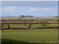
Farmland between Blunsdon and Highworth
The young crops in the foreground are probably cereal but could be oilseed. The area of high ground in the distance is Lus Hill (or Lushill) http://www.geograph.org.uk/photo/302561 This is a view to the north towards Gloucestershire.
Image: © Brian Robert Marshall
Taken: 22 Jan 2009
0.15 miles