IMAGES TAKEN NEAR TO
Lower Village, SWINDON, SN26 7BJ
Introduction
This page details the photographs taken nearby to Lower Village, SN26 7BJ by members of the Geograph project.
The Geograph project started in 2005 with the aim of publishing, organising and preserving representative images for every square kilometre of Great Britain, Ireland and the Isle of Man.

There are currently over 7.5m images from over14,400 individuals and you can help contribute to the project by visiting https://www.geograph.org.uk
Image Map
Images are licensed for reuse under creativecommons.org/licenses/by-sa/2.0
Notes
- Clicking on the map will re-center to the selected point.
- The higher the marker number, the further away the image location is from the centre of the postcode.
Image Listing (7 Images Found)
Images are licensed for reuse under creativecommons.org/licenses/by-sa/2.0
Image
Details
Distance
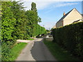
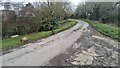
2
Back Lane, Broad Blunsdon
The back of the Lower Village, the other parallel road is Front Lane.
Image: © Robin Webster
Taken: 19 Jan 2020
0.06 miles
3
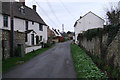
Cottages in Front Lane, Broad Blunsdon
Cottages line Front Lane, a narrow road which winds steeply uphill with a tiny stream running beside it.
Image: © Vieve Forward
Taken: 1 Jan 2012
0.06 miles
4
Back Lane, Blunsdon
Back Lane marks almost the most northerly residential part of the sprawling village of Blunsdon.
Image: © Brian Robert Marshall
Taken: 6 Mar 2014
0.06 miles
5
Another view of Back Lane, Blunsdon
It probably looks better in the summer.
Image: © Brian Robert Marshall
Taken: 6 Mar 2014
0.08 miles
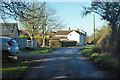
6

Longfield Farm
Entrance to Longfield Farm, Blunsdon.
Image: © Wayland Smith
Taken: 13 Jun 2020
0.09 miles
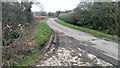
7
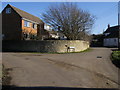
Back Lane
Back Lane junction with Front Lane
Image: © Shaun Ferguson
Taken: 25 Feb 2012
0.09 miles