IMAGES TAKEN NEAR TO
Downton Road, SWINDON, SN2 5JN
Introduction
This page details the photographs taken nearby to Downton Road, SN2 5JN by members of the Geograph project.
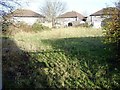
The Geograph project started in 2005 with the aim of publishing, organising and preserving representative images for every square kilometre of Great Britain, Ireland and the Isle of Man.

There are currently over 7.5m images from over14,400 individuals and you can help contribute to the project by visiting https://www.geograph.org.uk
Image Map
Images are licensed for reuse under creativecommons.org/licenses/by-sa/2.0
Notes
- Clicking on the map will re-center to the selected point.
- The higher the marker number, the further away the image location is from the centre of the postcode.
Image Listing (23 Images Found)
Images are licensed for reuse under creativecommons.org/licenses/by-sa/2.0
Image
Details
Distance
1
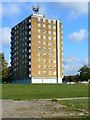
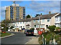
Seagry Court, Penhill, Swindon
The tower block is one of three such blocks in Penhill. Most of the estate was developed in the 1950s but I think the high-rise towers may only date to the 1960s. The estate remains largely under local authority control. The council have so far resisted the temptation to sell their housing stock to housing associations. In common with the other towers, the opportunity has been taken to lease the roof area to telecoms operators.
Image: © Brian Robert Marshall
Taken: 3 Oct 2008
0.04 miles
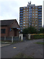
2
Penhill from Haydon View Road
The block of flats on the horizon is Seagry Court.
Image: © Vieve Forward
Taken: 9 Feb 2012
0.04 miles
3
Penhill Royal British Legion Club, Downton Road, Penhill
Penhill Royal British Legion Club (note the war memorial and Union flag in front of the Club). The branch was opened in 1967, and closed in 2010 after falling into debt. A fire caused severe damage to the derelict building in February 2012.
Image: © Vieve Forward
Taken: 18 Feb 2012
0.06 miles
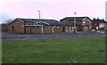
4
Penhill Gospel Hall and Seagry Court, Penhill
Image: © Vieve Forward
Taken: 18 Feb 2012
0.07 miles
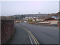
5
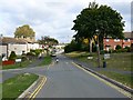
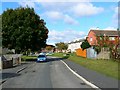
Downton Road, Penhill, Swindon
Penhill is a local authority housing estate developed in the early to mid 1950s. Swindon Borough Council took advantage of the Town Development Act 1952 to expand at a rapid rate in the post-war years. As with many other roads in Penhill, it is named after a town or village in Wiltshire. Downton is near Salisbury. The road leading away to the left is Minety Road. Its eponym is in north Wiltshire.
Image: © Brian Robert Marshall
Taken: 3 Oct 2008
0.08 miles
6
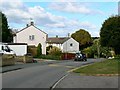
Westbury Road, Penhill, Swindon
Westbury Road is marked by the houses in the centre of the image. They are part of the 1950s local authority housing estate of Penhill. On the right skyline is Liddington Hill in SU2180.
Image: © Brian Robert Marshall
Taken: 3 Oct 2008
0.09 miles
7
Winterslow Road, Penhill, Swindon
Penhill is a local authority housing estate developed in the early to mid 1950s. Swindon Borough Council took advantage of the Town Development Act 1952 to expand at a rapid rate in the post-war years. Most of the houses are three bedroomed terraced but there are low-rise maisonettes and some high-rise development. This is a view to the western edge of the square.
Image: © Brian Robert Marshall
Taken: 3 Oct 2008
0.11 miles
8
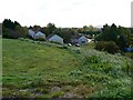
Minety Road, Penhill, Swindon
Penhill is a local authority housing estate developed in the early to mid 1950s. Swindon Borough Council took advantage of the Town Development Act 1952 to expand at a rapid rate in the post-war years. Most of Penhill sits on relatively high ground in the northern part of the town but falls away north into a valley through which a small watercourse runs. Minety Road takes the visitor into the valley.
Image: © Brian Robert Marshall
Taken: 3 Oct 2008
0.13 miles
10
Avebury Road, Penhill, Swindon
Penhill is a local authority housing estate developed in the early to mid 1950s. Swindon Borough Council took advantage of the Town Development Act 1952 to expand at a rapid rate in the post-war years. The theme for the naming of the roads and closes in the estate is Wiltshire towns and villages. Avebury is famous for its old rocks http://www.geograph.org.uk/photo/567773
Image: © Brian Robert Marshall
Taken: 3 Oct 2008
0.16 miles