IMAGES TAKEN NEAR TO
Tarka Close, SWINDON, SN25 4WA
Introduction
This page details the photographs taken nearby to Tarka Close, SN25 4WA by members of the Geograph project.
The Geograph project started in 2005 with the aim of publishing, organising and preserving representative images for every square kilometre of Great Britain, Ireland and the Isle of Man.

There are currently over 7.5m images from over14,400 individuals and you can help contribute to the project by visiting https://www.geograph.org.uk
Image Map
Images are licensed for reuse under creativecommons.org/licenses/by-sa/2.0
Notes
- Clicking on the map will re-center to the selected point.
- The higher the marker number, the further away the image location is from the centre of the postcode.
Image Listing (10 Images Found)
Images are licensed for reuse under creativecommons.org/licenses/by-sa/2.0
Image
Details
Distance
1

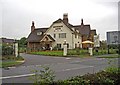
The Blunsdon Arms
One of several new pubs built to serve the incoming population of north Swindon.
Image: © Roger Cornfoot
Taken: 15 Jan 2007
0.06 miles
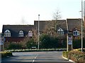
2
Blunsdon Arms, Thamesdown Drive, Swindon
As the town of Swindon has continued its growth to the west and the north, the Borough Council has ensured that provision is made for new public houses to serve the new communities. Thus Swindon probably has had more new pubs in its suburban estates in the last two decades, than any other place of comparable size. Some of these pubs have been converted from farmhouses, others have been new build. The Blunsdon Arms in the north of Swindon is an example of the latter. It belongs to the Ember Inns chain and is the first time they have built a entirely new pub. Although of a traditional design, the pub has an attractive appearance, and seems to be gaining customers since it opened around 2006. As well as stocking several real ales, the pub has a restaurant.
Although the pub's address is Thamesdown Drive, its access is from Lady Lane (the B4534). Like all Ember Inns, children under 14 are not admitted, and those 14 or over are only admitted if dining with an adult.
Image: © P L Chadwick
Taken: 27 Sep 2010
0.09 miles
3
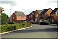
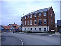
Pennine Way, St Andrew's Ridge, Swindon
Pennine Way meanders through the St Andrew's Ridge part of the Northern Expansion Area with smaller roads leading from it. It is all very artfully laid out with a minimum of straight lines. Here we can see a modern terrace of houses deliberately designed to have different roof heights.
Image: © Brian Robert Marshall
Taken: 16 Feb 2008
0.11 miles
4
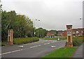
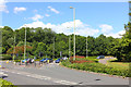
Lady Lane (B4534) near roundabout
Lady Lane is an old country road leading to the village of Blunsdon, which has now been engulfed for much of its length, by the ongoing massive northern expansion of Swindon. Here it is about to plough through some new residential estates. The roundabout is at the junction of Lady Lane with Sandstone Road, and Pennine Way. On the pillars are 20 mph speed restriction signs. These are frequently found in Swindon's new residential areas, and probably will eventually become the norm everywhere.
Image: © P L Chadwick
Taken: 27 Sep 2010
0.11 miles
6
Elstree Way
Road junction in Swindon.
Image: © Wayland Smith
Taken: 13 Jun 2020
0.13 miles
8
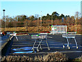
Car park, Orbital Retail Park, Swindon
The retail park is totally deserted today. I imagine 24 hours earlier this would have total mayhem with last-minute shoppers at the nearby Asda Walmart hyperstore loading up their cars and abandoning their trolleys where they will. The houses in the trees are in Viking Close, north of Thamesdown Drive.
Image: © Brian Robert Marshall
Taken: 25 Dec 2009
0.23 miles
9
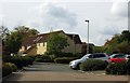
Conflicting styles at Blunsdon St Andrew
Typical of the mis-matches produced in the rapid expansion of Swindon in recent times. A 'city-style' apartment block overlooks a 'lego-style' primary school.
Image: © Roger Cornfoot
Taken: 15 Jan 2007
0.23 miles
10
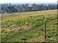
A view south-west from St Andrew's Ridge, Swindon
The area north of the established areas of Penhill and Haydon Wick and south of the village of Blunsdon is known generically as the Northern Expansion Area. It has been under development for several years from the early 1990s. Within the NEA are individual sub-areas with names such as St Andrew's Ridge, Redhouse and Priory Vale. I suspect they are mostly marketing-inspired though with a nod to existing names and features. Sadly, I can't remember many of them. In this view we can see the open space between St Andrew's Ridge behind the viewpoint and, I think, Redhouse, outside this square. The marker at the right indicates the presence of a bridleway.
Image: © Brian Robert Marshall
Taken: 16 Feb 2008
0.24 miles