IMAGES TAKEN NEAR TO
Emmanuel Close, SWINDON, SN25 3LX
Introduction
This page details the photographs taken nearby to Emmanuel Close, SN25 3LX by members of the Geograph project.
The Geograph project started in 2005 with the aim of publishing, organising and preserving representative images for every square kilometre of Great Britain, Ireland and the Isle of Man.

There are currently over 7.5m images from over14,400 individuals and you can help contribute to the project by visiting https://www.geograph.org.uk
Image Map
Images are licensed for reuse under creativecommons.org/licenses/by-sa/2.0
Notes
- Clicking on the map will re-center to the selected point.
- The higher the marker number, the further away the image location is from the centre of the postcode.
Image Listing (10 Images Found)
Images are licensed for reuse under creativecommons.org/licenses/by-sa/2.0
Image
Details
Distance
1
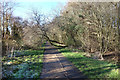
Tree on the Path
Bridleway and cycle path along the southern edge of the Seven Fields Nature Reserve.
Part of a series of pleasant off-road green routes which wind around the houses in this part of town.
Image: © Des Blenkinsopp
Taken: 19 Jan 2020
0.08 miles
2
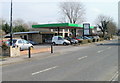
Greenmeadows Service Station, Swindon
Service station, MoTs, repairs and used cars bought and sold. Located on Thames Avenue, next door to the Shield & Dagger.
Image: © Jaggery
Taken: 12 Mar 2011
0.19 miles
3
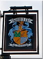
Swindon : Shield & Dagger pub sign
The pub http://www.geograph.org.uk/photo/2307750 sign is on the corner of Trent Road and Thames Avenue.
Image: © Jaggery
Taken: 12 Mar 2011
0.20 miles
4
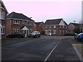
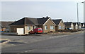
Bowles Road and Henman Close, Abbey Meads, Swindon
Henman Close is the street leading off to the left in the middle distance.
Image: © Vieve Forward
Taken: 18 Feb 2012
0.20 miles
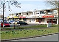
5
Corner of Severn Avenue and Thames Avenue, Haydon Wick, Swindon
Thames Avenue bungalows near the corner of Severn Avenue.
These street names are the nearest most of Swindon gets to a river. The River Ray http://www.geograph.org.uk/photo/1716191 flows past the western edge of the town. The River Thames is several kilometres north of the northern edge of Swindon.
Image: © Jaggery
Taken: 12 Mar 2011
0.21 miles
6
Shield and Dagger, Swindon
Pub built in the 1960s, located on the corner of Thames Avenue and Trent Road.
Image: © Jaggery
Taken: 12 Mar 2011
0.21 miles
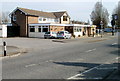
7
Shops on the corner of Trent Road and Thames Avenue, Swindon
Nearest the camera is Seven Star Chinese takeaway.
Image: © Jaggery
Taken: 12 Mar 2011
0.21 miles
8
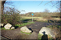
Half Moon Ground
Part of the Seven Fields Nature Reserve, an area of old meadow and woodland which is a remnant of the former farmland of this area before suburban Swindon arrived.
This entrance is off Kennet Avenue, a public road, hence the boulders to stop vehicle access.
The far boundary of the field follows the meander of a stream giving a roughly semi-circular shape, hence the name.
Image: © Des Blenkinsopp
Taken: 19 Jan 2020
0.21 miles
9
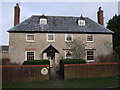
Haydon Wick Farmhouse, Pond Street, Haydon Wick
Grade II Listed former farmhouse, probably built in the 17th century, but altered in the mid-19th century. http://www.britishlistedbuildings.co.uk/en-318358-haydon-wick-farmhouse-haydon-wick
Image: © Vieve Forward
Taken: 18 Feb 2012
0.22 miles
10
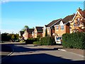
Oberon Way, Abbey Meads, Swindon
This pleasant suburban location is a crime scene. For some weeks cars parked hereabouts have been vandalised in an unusual fashion by having their anti-lock braking systems attacked. The perpetrators remained unidentified until recently when an off-duty police officer found teeth marks on the damaged parts of his car's brakes. Further forensic investigations confirmed that the offenders were of American extraction and members of the notorious Sciurus crime family http://www.swindonadvertiser.co.uk/news/8456675.Furry_vandal_drives_police_nuts/
Image: © Brian Robert Marshall
Taken: 17 Oct 2010
0.24 miles