IMAGES TAKEN NEAR TO
Don Close, SWINDON, SN25 3LS
Introduction
This page details the photographs taken nearby to Don Close, SN25 3LS by members of the Geograph project.
The Geograph project started in 2005 with the aim of publishing, organising and preserving representative images for every square kilometre of Great Britain, Ireland and the Isle of Man.

There are currently over 7.5m images from over14,400 individuals and you can help contribute to the project by visiting https://www.geograph.org.uk
Image Map
Images are licensed for reuse under creativecommons.org/licenses/by-sa/2.0
Notes
- Clicking on the map will re-center to the selected point.
- The higher the marker number, the further away the image location is from the centre of the postcode.
Image Listing (9 Images Found)
Images are licensed for reuse under creativecommons.org/licenses/by-sa/2.0
Image
Details
Distance
1
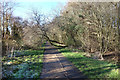
Tree on the Path
Bridleway and cycle path along the southern edge of the Seven Fields Nature Reserve.
Part of a series of pleasant off-road green routes which wind around the houses in this part of town.
Image: © Des Blenkinsopp
Taken: 19 Jan 2020
0.02 miles
2
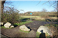
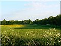
Half Moon Ground
Part of the Seven Fields Nature Reserve, an area of old meadow and woodland which is a remnant of the former farmland of this area before suburban Swindon arrived.
This entrance is off Kennet Avenue, a public road, hence the boulders to stop vehicle access.
The far boundary of the field follows the meander of a stream giving a roughly semi-circular shape, hence the name.
Image: © Des Blenkinsopp
Taken: 19 Jan 2020
0.13 miles
3
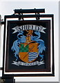
Swindon : Shield & Dagger pub sign
The pub http://www.geograph.org.uk/photo/2307750 sign is on the corner of Trent Road and Thames Avenue.
Image: © Jaggery
Taken: 12 Mar 2011
0.19 miles
4
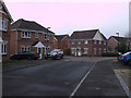
Bowles Road and Henman Close, Abbey Meads, Swindon
Henman Close is the street leading off to the left in the middle distance.
Image: © Vieve Forward
Taken: 18 Feb 2012
0.21 miles
5
Seven Fields, Greenmeadow, Swindon
This area is a nature reserve and recreation ground. To the right on the other side of the hedge is Kennet Avenue, the eastern edge of the Greenmeadow housing estate, privately developed in the 1960s.
Image: © Brian Robert Marshall
Taken: 13 May 2008
0.22 miles
6
Shield and Dagger, Swindon
Pub built in the 1960s, located on the corner of Thames Avenue and Trent Road.
Image: © Jaggery
Taken: 12 Mar 2011
0.22 miles
7
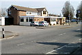
Shops on the corner of Trent Road and Thames Avenue, Swindon
Nearest the camera is Seven Star Chinese takeaway.
Image: © Jaggery
Taken: 12 Mar 2011
0.22 miles
8
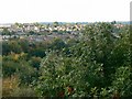
Penhill Copse, Swindon
The copse is part of the Seven Fields Local Nature Reserve situated between the estate of Penhill (providing the viewpoint) and Greenmeadow, a private housing estate built in the 1960s, visible in the background.
Image: © Brian Robert Marshall
Taken: 3 Oct 2008
0.24 miles
9
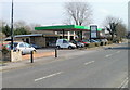
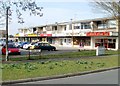
Greenmeadows Service Station, Swindon
Service station, MoTs, repairs and used cars bought and sold. Located on Thames Avenue, next door to the Shield & Dagger.
Image: © Jaggery
Taken: 12 Mar 2011
0.24 miles