IMAGES TAKEN NEAR TO
The Street, SWINDON, SN25 3HJ
Introduction
This page details the photographs taken nearby to The Street, SN25 3HJ by members of the Geograph project.
The Geograph project started in 2005 with the aim of publishing, organising and preserving representative images for every square kilometre of Great Britain, Ireland and the Isle of Man.

There are currently over 7.5m images from over14,400 individuals and you can help contribute to the project by visiting https://www.geograph.org.uk
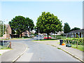
Image Map
Images are licensed for reuse under creativecommons.org/licenses/by-sa/2.0
Notes
- Clicking on the map will re-center to the selected point.
- The higher the marker number, the further away the image location is from the centre of the postcode.
Image Listing (15 Images Found)
Images are licensed for reuse under creativecommons.org/licenses/by-sa/2.0
Image
Details
Distance
1
Shanklin Road, Moredon, Swindon
The houses on the left are in Shanklin Road, part of a 1950s municipal housing estate. Those on the right are in Locksgreen Crescent.
Image: © Brian Robert Marshall
Taken: 2 Jul 2009
0.06 miles
2
The Brow, Haydon Wick, Swindon
Houses on the west side of The Brow, a gently rising road between The Street and High Street, Haydon Wick.
Image: © Jaggery
Taken: 12 Mar 2011
0.11 miles
3
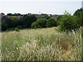
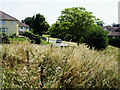
Green space, Ventnor Close, Moredon, Swindon
The green area is south of Ventor Close, part of the municipal housing estate developed in the 1950s. As far as I know is isn't a designated wildlife area. The houses in the distance are in Woodhall Park, a private housing estate built in the 1970s.
Image: © Brian Robert Marshall
Taken: 2 Jul 2009
0.12 miles
4
An entrance to Haydon Wick Primary School
The entrance to the school (and to Barn Own Pre-school) is from a road named The Brow. There is another entrance on the High Street side of the school.
Image: © Jaggery
Taken: 12 Mar 2011
0.13 miles
5
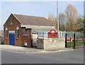
1st Swindon Sea Scouts hall, Haydon Wick
Located on a road named The Brow, next to an entrance http://www.geograph.org.uk/photo/2306696 to Haydon Wick Primary School.
Sea scouting traces its origins back to 1909. Its early development paralleled that of the land-based scouting movement. The majority of sea scout centres are in coastal areas, or near the Thames in London. However, there are groups in most inland counties, such as here in Wiltshire.
Image: © Jaggery
Taken: 12 Mar 2011
0.13 miles
6
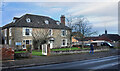
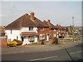
Park Farm, The Street
One of several older buildings along here which pre-date the 20th century suburban expansion which now covers most of this area.
Image: © Des Blenkinsopp
Taken: 30 Jan 2023
0.13 miles
7
Cheddar Road, Moredon, Swindon
This view is in the heart of Moredon, a municipal housing estate built in the 1950s. Cheddar Road leads away from the viewpoint to its junction with Barton Road on the left. The houses on the left are of the 'Cornish' design, one of several non-traditional building systems developed in the immediate post-war years to enable as many houses as possible to be built by local authorities in the shortest time. The design principles typically involved the use of reinforced concrete and the generic term 'PRC' for pre-cast reinforced concrete was coined to describe system-built housing. Unfortunately, the use of this material led to structural problems developing in the life of the properties and they had to be comprehensively rebuilt to enable their continued existence. The bungalows on the right are of more traditional design and construction and were built to accommodated retired people.
Image: © Brian Robert Marshall
Taken: 2 Jul 2009
0.17 miles
8
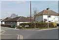
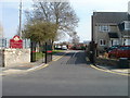
Left for High Street or right for High Street, Haydon Wick, Swindon
At the north end of a road named The Brow, signs direct you left for High Street ( mainly the odd-numbered houses) or right for (the older part of) High Street.
Image: © Jaggery
Taken: 12 Mar 2011
0.19 miles
9
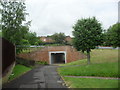
Haydon Wick
Underpass under Haydonleigh Drive.
Image: © Burgess Von Thunen
Taken: 6 Jun 2012
0.19 miles
10
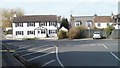
Corner of Blunsdon Road and High Street, Haydon Wick, Swindon
Viewed from High Street across the SW end of Blunsdon Road.
Image: © Jaggery
Taken: 12 Mar 2011
0.22 miles