IMAGES TAKEN NEAR TO
Barbury Close, SWINDON, SN25 3DR
Introduction
This page details the photographs taken nearby to Barbury Close, SN25 3DR by members of the Geograph project.
The Geograph project started in 2005 with the aim of publishing, organising and preserving representative images for every square kilometre of Great Britain, Ireland and the Isle of Man.

There are currently over 7.5m images from over14,400 individuals and you can help contribute to the project by visiting https://www.geograph.org.uk
Image Map
Images are licensed for reuse under creativecommons.org/licenses/by-sa/2.0
Notes
- Clicking on the map will re-center to the selected point.
- The higher the marker number, the further away the image location is from the centre of the postcode.
Image Listing (10 Images Found)
Images are licensed for reuse under creativecommons.org/licenses/by-sa/2.0
Image
Details
Distance
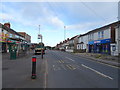
1
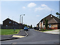
Coombe Road, Moredon, Swindon
Moredon is a municipal housing estate developed in the 1950s. Coombe Road, leading away from the viewpoint, contains terraced houses typical of many thousands built at the same time up and down the country by local authorities.
Image: © Brian Robert Marshall
Taken: 2 Jul 2009
0.10 miles
2
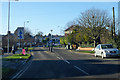
Abbey View Road, Moredon, Swindon
This part of Abbey View Road is on the eastern edge of Moredon, a municipal housing estate dating from the 1950s. The road is so named because it may once have been possible to see Blunsdon Abbey, a few kilometres to the north. The older houses in the background are in Church Walk North, in the Cheney Manor area of Swindon. These are private houses.
Image: © Brian Robert Marshall
Taken: 2 Jul 2009
0.15 miles
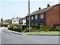
3
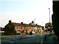
Cheddar Road, Moredon, Swindon
This view is in the heart of Moredon, a municipal housing estate built in the 1950s. Cheddar Road leads away from the viewpoint to its junction with Barton Road on the left. The houses on the left are of the 'Cornish' design, one of several non-traditional building systems developed in the immediate post-war years to enable as many houses as possible to be built by local authorities in the shortest time. The design principles typically involved the use of reinforced concrete and the generic term 'PRC' for pre-cast reinforced concrete was coined to describe system-built housing. Unfortunately, the use of this material led to structural problems developing in the life of the properties and they had to be comprehensively rebuilt to enable their continued existence. The bungalows on the right are of more traditional design and construction and were built to accommodated retired people.
Image: © Brian Robert Marshall
Taken: 2 Jul 2009
0.17 miles
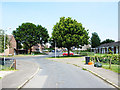
4
Fernham Road, Moredon, Swindon
Fernham Road is another road in the post-war Council estate of Moredon. Leaving it to the right is the entrance to Chilton Gardens, a sheltered housing scheme for elderly residents.
Image: © Brian Robert Marshall
Taken: 2 Jul 2009
0.18 miles
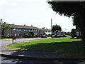
6
Houses in Moredon Road, Swindon
This terrace of houses in perhaps Edwardian or a little later. Moredon Road can be seen in the foreground and leading away to the right. The road exiting the mini-roundabout to the left is Bourne Road which leads into part of the post-war local authority-built Moredon estate.
Image: © Brian Robert Marshall
Taken: 13 May 2008
0.23 miles
7
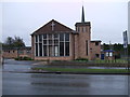
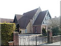
Saint Andrew's Methodist Church, Moredon Road
Formed in around 1962 following the amalgamation of the churches in Rodbourne Cheney, Moredon and Haydon Wick. http://www.standrewsmethodistchurchswindon.btck.co.uk/
Image: © Vieve Forward
Taken: 18 Feb 2012
0.23 miles
8
Emmanuel United Reformed Church, Haydon Wick
Modern building located at the eastern end of High Street. The church history can be traced back to 1849 (via many alterations), when a congregational chapel was built here. At that time, Haydon Wick was a hamlet to the north of Swindon.
Image: © Jaggery
Taken: 12 Mar 2011
0.23 miles
9
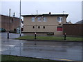
Rodbourne Cheney Workingmen's Club, Moredon Road
Image: © Vieve Forward
Taken: 18 Feb 2012
0.24 miles