IMAGES TAKEN NEAR TO
Iffley Road, SWINDON, SN2 1DL
Introduction
This page details the photographs taken nearby to Iffley Road, SN2 1DL by members of the Geograph project.
The Geograph project started in 2005 with the aim of publishing, organising and preserving representative images for every square kilometre of Great Britain, Ireland and the Isle of Man.

There are currently over 7.5m images from over14,400 individuals and you can help contribute to the project by visiting https://www.geograph.org.uk
Image Map
Images are licensed for reuse under creativecommons.org/licenses/by-sa/2.0
Notes
- Clicking on the map will re-center to the selected point.
- The higher the marker number, the further away the image location is from the centre of the postcode.
Image Listing (126 Images Found)
Images are licensed for reuse under creativecommons.org/licenses/by-sa/2.0
Image
Details
Distance
1
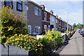
Iffley Road, Rodbourne
A line of terraced houses stretches away along the south side of Iffley Road.
Image: © Stephen McKay
Taken: 15 Jul 2022
0.04 miles
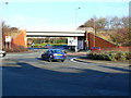
2
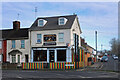
Caribbean Corner, Rodbourne Road
A Jamaican restaurant on the corner of Rodbourne and Iffley Roads.
Image: © Des Blenkinsopp
Taken: 30 Jan 2023
0.04 miles
4
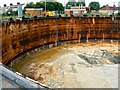
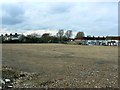
Site of gasholder, Iffley Road, Swindon (1 of 5) 08 August 2013
Access by permission. The bottom of the hole can at last be seen. As bottoms go, one of the less exciting ones I've encountered albeit larger, and soon to be covered up.
NOTE. This image has a detailed ‘shared description’ which you won’t see by viewing this image on a slideshow. To read it click on the image.
Image: © Brian Robert Marshall
Taken: 8 Aug 2013
0.08 miles
5
Site of gasholder, Iffley Road, Swindon 05 March 2014
A few months on from the last time I was here http://www.geograph.org.uk/photo/3589889 and the view has changed somewhat. The site is still fenced off and this photo was taken from above the locked access gate. It remains to be seen what will happen here, if anything.
Image: © Brian Robert Marshall
Taken: 5 Mar 2014
0.08 miles
6
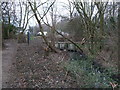
Disused Wilts & Berks Canal (North Wilts Branch) near Bruce Street Bridges
The disused North Wilts branch of the Wilts & Berks Canal is truncated at Bruce Street Bridges, but north of this point forms a small and a large pond, the latter now used for coarse fishing. The North Wilts branch formerly connected the main Wilts & Berks Canal with the Thames and Severn Canal, and ran between Swindon and Latton.
Image: © Vieve Forward
Taken: 23 Feb 2012
0.08 miles
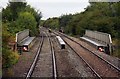
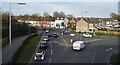
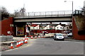
8
Bruce Street Bridges, Rodbourne, Swindon
The bridge is one of two in close proximity that carry the road network beneath the Swindon to Gloucester railway. This is the easternmost bridge. The bridge complex is best appreciated from the aerial view in Google Earth.
Image: © Brian Robert Marshall
Taken: 17 Jan 2010
0.09 miles
9
One of the Bruce Street Bridges, Swindon
Located near Great Western Way, this bridge carries railway lines over the B4289 in the SE corner of the major Bruce Street Bridges junction. This is one of the key railway crossing points within the town, connecting north Swindon with the town centre. The existing traffic-flow arrangement is a four mini-roundabout junction, with two roundabouts either side of the railway line which runs through the centre. Great Western Way is one of the busiest roads in Swindon, used by c19,000 vehicles daily. It is also the diversion route for the M4 when motorway closures are necessary between junctions 15 and 16.
In March 2015, work is in progress on a 12-month improvements scheme to increase the traffic flow through this area. Work is scheduled to end in September 2015.
Image: © Jaggery
Taken: 15 Mar 2015
0.09 miles
10
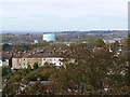
Gasholder, Iffley Road, Swindon
The gasholder is the light blue structure near the centre of the image. It has been re-painted since the last time I photographed it http://www.geograph.org.uk/photo/323249 Also visible in front of the gasholder is St Mark's church, several images of which are in Image The houses in the middle are in Exmouth Street in the same square as the church.
Image: © Brian Robert Marshall
Taken: 29 Oct 2007
0.09 miles