IMAGES TAKEN NEAR TO
Mill Lane, SWINDON, SN1 7HG
Introduction
This page details the photographs taken nearby to Mill Lane, SN1 7HG by members of the Geograph project.
The Geograph project started in 2005 with the aim of publishing, organising and preserving representative images for every square kilometre of Great Britain, Ireland and the Isle of Man.

There are currently over 7.5m images from over14,400 individuals and you can help contribute to the project by visiting https://www.geograph.org.uk
Image Map
Images are licensed for reuse under creativecommons.org/licenses/by-sa/2.0
Notes
- Clicking on the map will re-center to the selected point.
- The higher the marker number, the further away the image location is from the centre of the postcode.
Image Listing (43 Images Found)
Images are licensed for reuse under creativecommons.org/licenses/by-sa/2.0
Image
Details
Distance
1
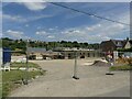
New house building, West Leaze
Adjacent to West Leaze Farm.
Image: © Alan Murray-Rust
Taken: 13 Jul 2022
0.03 miles
2
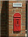
EVIIR lamp box, West Leaze
A rare type, which has survived redundancy to become a private letter box.
Image: © Alan Murray-Rust
Taken: 13 Jul 2022
0.03 miles
3
3 Westleaze
House on Mill Lane at West Leaze.
Image: © Ian Capper
Taken: 14 Jul 2022
0.05 miles
4
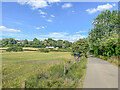
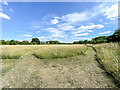
Off Mill Lane
Field off Mill Lane at West Leaze, part of which is earmarked for inclusion in the Wichelstowe housing development.
Image: © Ian Capper
Taken: 14 Jul 2022
0.08 miles
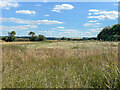
5
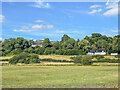
Off Mill Lane
Field off Mill Lane with houses in Field Rise in the background and aWulfric House, completed in 2022, below. Running across the field is the River Ray.
Image: © Ian Capper
Taken: 14 Jul 2022
0.08 miles
6
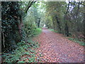
Mill Lane
Lane connecting West Leaze and the Swindon suburb of Okus and on to Old Town, seen here before it passes under Old Town Cycle Path. Until recently it was a through route, but it was closed in 2021 to avoid it being used as a rat run and lorry route for the new housing development at Wichelstowe, at the same time creating a quiet route for cyclists and pedestrians.
Image: © Ian Capper
Taken: 14 Jul 2022
0.09 miles
7
Swindon: Dismantled railway line near Okus
This is the trackbed of part of the dismantled former Midland and South Western Junction Railway (M&SWJR) between Swindon Town and Cirencester stations. It was open for passenger traffic between 1883 and 1961.
Looking in the direction of the former Swindon Town station, this is now part of the National Cycle Network Route 45, which will eventually connect Salisbury in Wiltshire with Chester in Cheshire, via Swindon, Cirencester, Gloucester, Worcester and Whitchurch.
Image: © Nigel Cox
Taken: 26 Oct 2007
0.09 miles
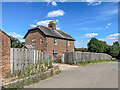
8
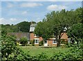
West Leaze Farmhouse
Early 19th century farmhouse, Listed Grade II. The listing suggest that it was developed as a result of the construction of the Wilts and Berks Canal. (This is the only available viewpoint from the public highway.)
Image: © Alan Murray-Rust
Taken: 13 Jul 2022
0.10 miles
9
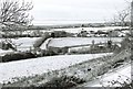
Mill Lane, Swindon, in winter
Mill Lane, covered in snow, can be seen in the immediate foreground, then in the middle of the picture, before it makes a sharp right turn. Perhaps the past tense should be used, because much of this road is likely to disappear and maybe already has. Mill Lane had the misfortune to be sitting in the middle of Swindon's so-called "front garden". This was the area of land, mainly farmland, on the south side of Swindon, sitting between the old railway line (from where this photo was taken) and the M4 motorway. It was called a garden, because it was envisaged it would remain a very pleasant green buffer between the built-up area and the motorway. But a combination of factors over-turned this, and now the area is to be developed, but probably in slow motion, because of the present economic climate.
Image: © P L Chadwick
Taken: Unknown
0.11 miles
10
Off Mill Lane
Field off Mill Lane with houses in Dunsley Vale, East Wichel, in the left background.
Image: © Ian Capper
Taken: 14 Jul 2022
0.11 miles