IMAGES TAKEN NEAR TO
Powell Rise, MALMESBURY, SN16 9XZ
Introduction
This page details the photographs taken nearby to Powell Rise, SN16 9XZ by members of the Geograph project.
The Geograph project started in 2005 with the aim of publishing, organising and preserving representative images for every square kilometre of Great Britain, Ireland and the Isle of Man.

There are currently over 7.5m images from over14,400 individuals and you can help contribute to the project by visiting https://www.geograph.org.uk
Image Map
Images are licensed for reuse under creativecommons.org/licenses/by-sa/2.0
Notes
- Clicking on the map will re-center to the selected point.
- The higher the marker number, the further away the image location is from the centre of the postcode.
Image Listing (7 Images Found)
Images are licensed for reuse under creativecommons.org/licenses/by-sa/2.0
Image
Details
Distance
1
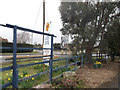
Public footpath through a field, Filands, Malmesbury
The public footpath is a barely discernible track from the west side of the B4014,
past vegetation growing on the bank of a small unnamed stream.
Image: © Jaggery
Taken: 17 Aug 2014
0.16 miles
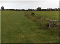
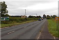
2
B4014 Filands, Malmesbury
The B4014 here follows a rural route along the northern edge of Malmesbury.
Image: © Jaggery
Taken: 17 Aug 2014
0.18 miles
3
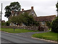
Orchard House, Filands, Malmesbury
Alongside the B4014 near Filands Farm.
Image: © Jaggery
Taken: 17 Aug 2014
0.19 miles
4
Filands Farm, Malmesbury
On the north side of the B4014 at the northern edge of Malmesbury.
Image: © Jaggery
Taken: 17 Aug 2014
0.20 miles
5
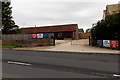
Filands View, Malmesbury
A new development on the north of Malmesbury, taking its name from a local farm Image
Image: © David Smith
Taken: 8 Jun 2018
0.22 miles
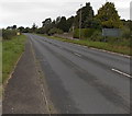
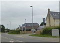
6
Towards a T junction in the north of Malmesbury
Looking SE along the B4014 Filands.
Image: © Jaggery
Taken: 17 Aug 2014
0.22 miles