IMAGES TAKEN NEAR TO
Hankerton, MALMESBURY, SN16 9LH
Introduction
This page details the photographs taken nearby to SN16 9LH by members of the Geograph project.
The Geograph project started in 2005 with the aim of publishing, organising and preserving representative images for every square kilometre of Great Britain, Ireland and the Isle of Man.

There are currently over 7.5m images from over14,400 individuals and you can help contribute to the project by visiting https://www.geograph.org.uk
Image Map
Images are licensed for reuse under creativecommons.org/licenses/by-sa/2.0
Notes
- Clicking on the map will re-center to the selected point.
- The higher the marker number, the further away the image location is from the centre of the postcode.
Image Listing (5 Images Found)
Images are licensed for reuse under creativecommons.org/licenses/by-sa/2.0
Image
Details
Distance
1
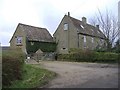
Laurel farm, Cloatley End
North of the minor road from Hankerton to Minety.
Image: © Roger Cornfoot
Taken: 29 Jan 2007
0.00 miles
2
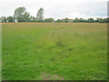
Meadow at Cloatley End
Looking north across a large flat grazing meadow, one of several in this area. Rooftops of Laurel Farm at the far end.
Image: © Trevor Rickard
Taken: 13 Jul 2011
0.09 miles
3
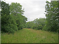
Public bridleway at Cloatley End
Looking north-east along what looks like an old farm track. Clearly not used by farmers, horses or even by walkers as there was no evidence of disturbance.
Image: © Trevor Rickard
Taken: 13 Jul 2011
0.17 miles
4
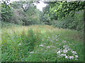
Overgrown route at Cloatley
Looking west along what was once a green lane or farm track. Quite heavy going as I was clearly the only one to pass by here for a long time. Very much an unofficial nature reserve.
Image: © Trevor Rickard
Taken: 13 Jul 2011
0.18 miles
5
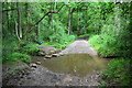
Ford at Fisteridge Wood
This ford and tree swing are found at the edge of Fisteridge Wood.
Image: © John Walton
Taken: 4 Jun 2017
0.25 miles