IMAGES TAKEN NEAR TO
Charlton Road, MALMESBURY, SN16 9JJ
Introduction
This page details the photographs taken nearby to Charlton Road, SN16 9JJ by members of the Geograph project.
The Geograph project started in 2005 with the aim of publishing, organising and preserving representative images for every square kilometre of Great Britain, Ireland and the Isle of Man.

There are currently over 7.5m images from over14,400 individuals and you can help contribute to the project by visiting https://www.geograph.org.uk
Image Map
Images are licensed for reuse under creativecommons.org/licenses/by-sa/2.0
Notes
- Clicking on the map will re-center to the selected point.
- The higher the marker number, the further away the image location is from the centre of the postcode.
Image Listing (32 Images Found)
Images are licensed for reuse under creativecommons.org/licenses/by-sa/2.0
Image
Details
Distance
1
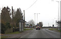
B4040 approaching A429 junction
Immediately south of Garden Centre
Image: © John Firth
Taken: 11 Apr 2013
0.01 miles
2
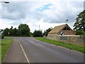
Junction, Milbourne
Milbourne Lane meets Charlton Road at a T-junction.
Image: © Derek Harper
Taken: 19 Jul 2011
0.02 miles
3
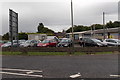
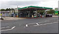
M L Curtis (Cars), Malmesbury
Car sales business in Crudwell Road, alongside a BP service station. http://www.geograph.org.uk/photo/4129298
Image: © Jaggery
Taken: 17 Aug 2014
0.06 miles
4
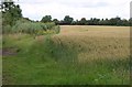
Wheat at Milbourne
A field of wheat adjoining housing at Milbourne Lane.
Image: © Derek Harper
Taken: 19 Jul 2011
0.07 miles
5
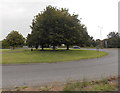
Trees on Whychurch roundabout, Malmesbury
Three tree trunks but the impression of one huge leaf canopy.
Image: © Jaggery
Taken: 17 Aug 2014
0.07 miles
6
BP service station, Crudwell Road, Malmesbury
BP filling station and shop viewed across the A429 Crudwell Road, near Whychurch roundabout.
Image: © Jaggery
Taken: 17 Aug 2014
0.08 miles
7
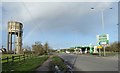
Water tower and petrol station near Whychurch Farm roundabout
Image: © Vieve Forward
Taken: 1 Feb 2020
0.10 miles
8
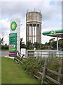
Water tower and service station near Malmesbury
The BP station is on the northeast side of the Whychurch roundabout. The water tower also appears in Image and Image In between them is the A429.
Image: © Derek Harper
Taken: 19 Jul 2011
0.10 miles
9
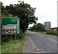
Destinations sign north of Malmesbury
The sign is alongside the A429 Crudwell Road, north of Whychurch roundabout.
Image: © Jaggery
Taken: 17 Aug 2014
0.11 miles
10
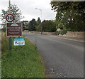
NE boundary of Malmesbury
Alongside the B4040 near Whychurch roundabout and Whychurch Farm.
The boundary sign states that Malmesbury's Charter (from King Alfred the Great) dates from 880 A.D.
Image: © Jaggery
Taken: 17 Aug 2014
0.11 miles