IMAGES TAKEN NEAR TO
Brokenborough, MALMESBURY, SN16 0HU
Introduction
This page details the photographs taken nearby to SN16 0HU by members of the Geograph project.
The Geograph project started in 2005 with the aim of publishing, organising and preserving representative images for every square kilometre of Great Britain, Ireland and the Isle of Man.

There are currently over 7.5m images from over14,400 individuals and you can help contribute to the project by visiting https://www.geograph.org.uk
Image Map
Images are licensed for reuse under creativecommons.org/licenses/by-sa/2.0
Notes
- Clicking on the map will re-center to the selected point.
- The higher the marker number, the further away the image location is from the centre of the postcode.
Image Listing (8 Images Found)
Images are licensed for reuse under creativecommons.org/licenses/by-sa/2.0
Image
Details
Distance
1
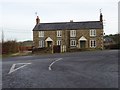
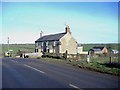
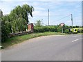
Cottages at Sunset Hill
Semi-detached cottages at Sunset Hill on the B4014 near Brokenborough.
Image: © Philip Halling
Taken: 4 Dec 2018
0.01 miles
3
Postbox near Brokenborough
George VI postbox in brick built pillar. For location see Image]
Image: © Maigheach-gheal
Taken: 1 Jul 2009
0.02 miles
4
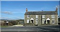
Sunset Hill cottages
Standing next to a fast section of the B4014 from Malmesbury to Tetbury.
Image: © Roger Cornfoot
Taken: 25 Jan 2007
0.02 miles
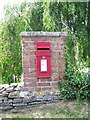
5
Postbox near Brokenborough
George VI postbox at the junction of a minor road with the B4014, Sunset Hill.
Image: © Maigheach-gheal
Taken: 1 Jul 2009
0.03 miles
6
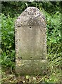
Old Milestone by the B4014, Tetbury Road, Brokenborough parish
Stone post (plate lost) by the B4014 (was A434), in parish of BROKENBOROUGH (NORTH WILTSHIRE District), Tetbury Road, top of Sunset Hill, 100m South of turning to Brokenborough, on verge, on West side of road. Malmesbury First marker, erected by the Malmesbury - First District turnpike trust in the 19th century.
Inscription once read:-
(TETBURY)
(3)
(MILES)
(MALMESB.Y)
(2)
(MILES)
Grade II listed.
List Entry Number: 1198626 https://historicengland.org.uk/listing/the-list/list-entry/1198626
Milestone Society National ID: WI_MYTB02.
Image: © M Faherty
Taken: 21 Jul 2007
0.07 miles
7
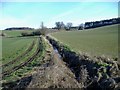
Gilboa farm
A brook, feeding the River Avon, cuts through the middle of the farm.
Image: © Roger Cornfoot
Taken: 25 Jan 2007
0.14 miles
8
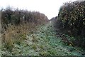
Bridleway at Brokenborough
A short bridleway at Brokenborough leading through to the B4014.
Image: © Philip Halling
Taken: 4 Dec 2018
0.18 miles