IMAGES TAKEN NEAR TO
Corston, MALMESBURY, SN16 0HJ
Introduction
This page details the photographs taken nearby to SN16 0HJ by members of the Geograph project.
The Geograph project started in 2005 with the aim of publishing, organising and preserving representative images for every square kilometre of Great Britain, Ireland and the Isle of Man.

There are currently over 7.5m images from over14,400 individuals and you can help contribute to the project by visiting https://www.geograph.org.uk
Image Map
Images are licensed for reuse under creativecommons.org/licenses/by-sa/2.0
Notes
- Clicking on the map will re-center to the selected point.
- The higher the marker number, the further away the image location is from the centre of the postcode.
Image Listing (20 Images Found)
Images are licensed for reuse under creativecommons.org/licenses/by-sa/2.0
Image
Details
Distance
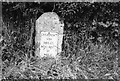
1
Old Milestone A429, Corston
Modern image of Image
The plate has disappeared since 1970.
Malmesbury First Roman stone and plate, by the A429, in parish of St Paul Malmesbury Without (North Wiltshire District), Malmesbury Road, North East side of the village, by the North West side of road.
There is most likely an OS Benchmark representing 75.1 m ASL on the front face under the soil.
Inscription reads: CHIPPENᴹ. / VIII / MILES / MALMSRY. / II /MILES
Grade II listed. July 1987 Number: 1284651 https://historicengland.org.uk/listing/the-list/list-entry/1284651
Milestone Society National ID: WI_CPMY08
Image: © Tom Blanden
Taken: 11 Nov 2022
0.04 miles
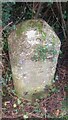
2
Old Milestone by the A429, Corston
Malmesbury First District Turnpike Trust, stone and plate (now lost) with Roman numerals, by the A429.
In parish of St Paul Malmesbury Without (North Wiltshire District), Malmesbury Road, North East side of the village, by the North West side of road.
The 2022 image, without plate, is Image
Inscription reads:-
CHIPPENM.
VIII
MILES
MALMSRY.
II
MILES
Grade II listed. July 1987 Number: 1284651
https://historicengland.org.uk/listing/the-list/list-entry/1284651
Milestone Society National ID: WI_CPMY08
Image: © Milestone Society
Taken: Unknown
0.04 miles
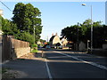
3
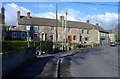
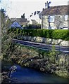
Corston cottages
Situated near the Gauze Brook bridge, at a bend in the A429.
Image: © Roger Cornfoot
Taken: 24 Jan 2007
0.11 miles
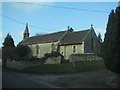
4
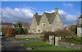
The Gables, Corston
One of the older village houses.
Image: © Roger Cornfoot
Taken: 24 Jan 2007
0.19 miles
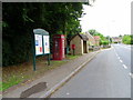
5
Mill Lane, Corston
Runs alongside the Gauze Brook.
Image: © Roger Cornfoot
Taken: 24 Jan 2007
0.19 miles