IMAGES TAKEN NEAR TO
Courtsknap Court, SWINDON, SN1 5JL
Introduction
This page details the photographs taken nearby to Courtsknap Court, SN1 5JL by members of the Geograph project.
The Geograph project started in 2005 with the aim of publishing, organising and preserving representative images for every square kilometre of Great Britain, Ireland and the Isle of Man.

There are currently over 7.5m images from over14,400 individuals and you can help contribute to the project by visiting https://www.geograph.org.uk
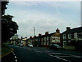
Image Map
Images are licensed for reuse under creativecommons.org/licenses/by-sa/2.0
Notes
- Clicking on the map will re-center to the selected point.
- The higher the marker number, the further away the image location is from the centre of the postcode.
Image Listing (178 Images Found)
Images are licensed for reuse under creativecommons.org/licenses/by-sa/2.0
Image
Details
Distance
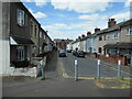
1
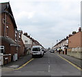
Dean Street, Swindon
Looking SW from Park Lane.
Image: © Jaggery
Taken: 15 Mar 2015
0.09 miles
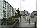
2
Birch Street, Swindon
Birch Street is one of many streets developed in the late Victorian years by speculative builders. The building in the centre is a pub that for many years was called 'The Ship'. It now goes by the name Bar 12. The Ship was the scene of a murder on 18 September 1903. More information here Image
Image: © Brian Robert Marshall
Taken: 16 Sep 2008
0.10 miles
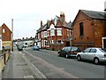
4
Marlborough Street, Swindon
On the north bank of the former Wilts & Berks canal. Built between 1885 and 1899. The canal closed in 1914.
Image: © Christine Johnstone
Taken: 14 Jul 2022
0.10 miles
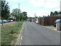
5
Read Street, Swindon
On the north bank of the former Wilts & Berks canal. Built between 1885 and 1899. The canal closed in 1914.
Image: © Christine Johnstone
Taken: 14 Jul 2022
0.12 miles
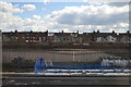
6
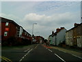
Faringdon Road, Swindon
Faringdon Road is one of the strategic intra-Swindon traffic routes as well as providing the main corridor into the centre of the town from the west, the direction in which we are facing. The houses at the left are relatively unusual for Victorian Swindon in that they are stone- rather than brick-built. The pub in the background is now the Bar12, formerly The Ship.
Image: © Brian Robert Marshall
Taken: 16 Sep 2008
0.12 miles
7
The former Wilts & Berks canal, heading south-west
Between Westcott Place and Albion Street, Swindon. The Wilts & Berks canal opened in 1810, linking the Kennet & Avon canal with the River Thames and running right through Swindon. It closed in 1914, but is now partly restored.
Image: © Christine Johnstone
Taken: 14 Jul 2022
0.12 miles
10
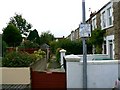
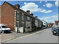
Cambria Place, Swindon
This terrace of houses is at the southern edge of the small but distinctive area of Victorian houses built by the Great Western Railway specifically for Welsh workers and their families. This is a view to the west. Car parking in the central area of Swindon is at a premium.
Image: © Brian Robert Marshall
Taken: 16 Sep 2008
0.13 miles