IMAGES TAKEN NEAR TO
Jolliffe Street, SWINDON, SN1 5HF
Introduction
This page details the photographs taken nearby to Jolliffe Street, SN1 5HF by members of the Geograph project.
The Geograph project started in 2005 with the aim of publishing, organising and preserving representative images for every square kilometre of Great Britain, Ireland and the Isle of Man.

There are currently over 7.5m images from over14,400 individuals and you can help contribute to the project by visiting https://www.geograph.org.uk
Image Map
Images are licensed for reuse under creativecommons.org/licenses/by-sa/2.0
Notes
- Clicking on the map will re-center to the selected point.
- The higher the marker number, the further away the image location is from the centre of the postcode.
Image Listing (322 Images Found)
Images are licensed for reuse under creativecommons.org/licenses/by-sa/2.0
Image
Details
Distance
1
Corner of Park Lane and Dean Street, Swindon
Park Lane is on the left.
Image: © Jaggery
Taken: 15 Mar 2015
0.06 miles
2
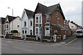
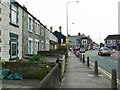
Birch Street, Swindon
Birch Street is one of many streets developed in the late Victorian years by speculative builders. The building in the centre is a pub that for many years was called 'The Ship'. It now goes by the name Bar 12. The Ship was the scene of a murder on 18 September 1903. More information here Image
Image: © Brian Robert Marshall
Taken: 16 Sep 2008
0.07 miles
3
Looking from Park Lane into Dean Street
Image: © Basher Eyre
Taken: 14 Jul 2022
0.07 miles
4

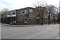
Territorial Army Centre, Church Place, Swindon
This relatively modern building is situated on the site of a drill hall built in 1871. The original drill hall had an area of 8000 square feet (743 square metres). The 1871 building was itself a replacement facility for an even earlier one Image built in 1861 and then converted ten years later into a hospital.
Image: © Brian Robert Marshall
Taken: 16 Mar 2014
0.07 miles
5
Military building on a Swindon corner
On the corner of Park Lane and Church Place. Names in view include
The Royal Yeomanry; 7 Rifles, Rifle Platoon; Wiltshire ACF (Army Cadet Force).
Image: © Jaggery
Taken: 15 Mar 2015
0.07 miles
6
Rodbourne Road at Park Lane junction
There is an OS benchmark Image on the brick wall on the left hand side of the image about 1 foot near of the black lamppost
Image: © Roger Templeman
Taken: 15 Mar 2016
0.07 miles
7
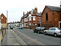
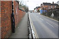
Faringdon Road, Swindon
Faringdon Road is one of the strategic intra-Swindon traffic routes as well as providing the main corridor into the centre of the town from the west, the direction in which we are facing. The houses at the left are relatively unusual for Victorian Swindon in that they are stone- rather than brick-built. The pub in the background is now the Bar12, formerly The Ship.
Image: © Brian Robert Marshall
Taken: 16 Sep 2008
0.08 miles
8

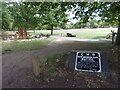
Catalpa tree in bloom in Faringdon Road Park
The park was developed by the Great Western Railway as New Swindon Park.
Image: © Alan Murray-Rust
Taken: 14 Jul 2022
0.08 miles
9
Historic sign in New Swindon Park
At the 2022 Geograph Meet, we had a fascinating talk about what GWR did for Swindon https://www.countryfile.com/countryfile/railway-town-swindon-wiltshire/
Image: © Basher Eyre
Taken: 14 Jul 2022
0.08 miles