IMAGES TAKEN NEAR TO
Harding Street, SWINDON, SN1 5BZ
Introduction
This page details the photographs taken nearby to Harding Street, SN1 5BZ by members of the Geograph project.
The Geograph project started in 2005 with the aim of publishing, organising and preserving representative images for every square kilometre of Great Britain, Ireland and the Isle of Man.

There are currently over 7.5m images from over14,400 individuals and you can help contribute to the project by visiting https://www.geograph.org.uk
Image Map
Images are licensed for reuse under creativecommons.org/licenses/by-sa/2.0
Notes
- Clicking on the map will re-center to the selected point.
- The higher the marker number, the further away the image location is from the centre of the postcode.
Image Listing (841 Images Found)
Images are licensed for reuse under creativecommons.org/licenses/by-sa/2.0
Image
Details
Distance
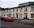
1
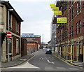
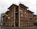
Harding Street, Swindon
Viewed from East Street. Scaffolding encases Harding House. http://www.geograph.org.uk/photo/4387887
Image: © Jaggery
Taken: 15 Mar 2015
0.01 miles
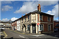
2
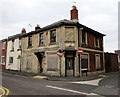
Derelict corner of Harding Street and East Street, Swindon
Viewed in mid-March 2015. Perhaps formerly a pub or other commercial premises.
Image: © Jaggery
Taken: 15 Mar 2015
0.02 miles
3
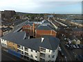
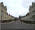
Modern housing and Brunel's Railway Town
View slightly south of west from Holiday Inn Express, looking towards the regular street of Railway Town
Image: © David Smith
Taken: 18 Oct 2012
0.03 miles
4
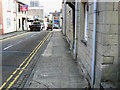
South-east along East Street, Swindon
At the lower right of the image is this cut mark Image The properties to the right represent the eastern extremity of I K Brunel's Railway Village, an early example of a housing development constructed specifically for the use of industrial workers and their families. It dates to the mid 19th century and was used in conjunction with the Great Western Railway factory nearby. The estate was sold in the 1970s to the local authority who modernised it and put the housing into their stock where they largely remain. I'm not sure if the 'right to buy' legislation of the 1980s applied to these dwellings. The houses on the left are rather later and were put up by speculative builders.
Image: © Brian Robert Marshall
Taken: 21 Sep 2010
0.03 miles
5
Scaffolding on Harding House, Swindon
Block of flats on the corner of Harding Street and East Street viewed in mid March 2015.
Image: © Jaggery
Taken: 15 Mar 2015
0.03 miles
6

Corner of Oxford Street and East Street, Swindon
Part of the Railway Village built by the Great Western Railway
in the mid 19th century to house its employees near its main railway works.
Image: © Jaggery
Taken: 15 Mar 2015
0.03 miles
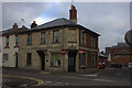
7
Looks like an Old Pub
On the corner of Harding and East Streets, this is the same place 8 years on as seen in Image
It was looking worse then, with doors and windows boarded up. Those have gone and there seem to be some curtains in the windows, but it's still looking sorry for itself.
Image: © Des Blenkinsopp
Taken: 17 Oct 2022
0.03 miles
8
Oxford Street, Swindon
From Emlyn Square looking towards East Street.
Oxford Street is part of the Railway Village built by the Great Western Railway
in the mid 19th century to house its employees near its main railway works.
Image: © Jaggery
Taken: 15 Mar 2015
0.03 miles
9
Oxford Street and East Street junction
This looks like it was once a pub.
Image: © Robert Eva
Taken: 6 Dec 2017
0.03 miles
10
Sheppard Street B&B, Swindon
Bed & breakfast accommodation at 11 Sheppard Street on the right.
Image: © Jaggery
Taken: 15 Mar 2015
0.03 miles