IMAGES TAKEN NEAR TO
Malmesbury Road, CHIPPENHAM, SN15 5QA
Introduction
This page details the photographs taken nearby to Malmesbury Road, SN15 5QA by members of the Geograph project.
The Geograph project started in 2005 with the aim of publishing, organising and preserving representative images for every square kilometre of Great Britain, Ireland and the Isle of Man.

There are currently over 7.5m images from over14,400 individuals and you can help contribute to the project by visiting https://www.geograph.org.uk
Image Map
Images are licensed for reuse under creativecommons.org/licenses/by-sa/2.0
Notes
- Clicking on the map will re-center to the selected point.
- The higher the marker number, the further away the image location is from the centre of the postcode.
Image Listing (26 Images Found)
Images are licensed for reuse under creativecommons.org/licenses/by-sa/2.0
Image
Details
Distance
1
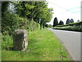
Milestone near the Kingtons
An old roadside sentinel remains on duty despite the fact that the road here is now little used after the A350 dual carriageway was built across the way in the recent past. See Image] for a closer look.
Image: © Neil Owen
Taken: 29 May 2021
0.07 miles
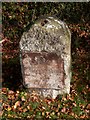
2
Two miles to Chippenham
A surviving milestone to the north of the town. The plate seems quite old but in older times it also included 'Malmesbury, 8 miles'. See Image] for a wide view along the road.
Image: © Neil Owen
Taken: 29 May 2021
0.07 miles
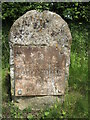
3
Old Milestone by the A483, north of Chippenham
Metal plate attached to stone post by the UC road (was A429), in parish of Kington Langley (North Wiltshire District), Old Malmesbury Road, 90m North of entry to Heathlands, on the verge, on East side of road. Chippenham plate, erected by the Malmesbury - First District turnpike trust in the 19th century.
Inscription reads:-
To
Chippenham
2
Grade II listed.
List Entry Number: 1022319 https://historicengland.org.uk/listing/the-list/list-entry/1022319
Milestone Society National ID: WI_CPMY02
Image: © Paul Gilman
Taken: 28 Oct 2015
0.07 miles
4
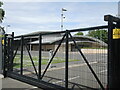
A secure church
This site has strong fencing, surveillance cameras, a gate intercom, sweeping windowless architecture and a general sense of fortification. It could be a government or military installation but is in fact a massive new church. This former picnic area is now owned by the Plymouth Brethren. The security is to keep the evils of the world out.
Image: © Neil Owen
Taken: 29 May 2021
0.11 miles
5
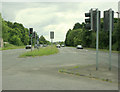
2009 : A429 south at Plough Lane
Subtitle: The uglification of Wiltshire.
The intrepid geographer risks life and limb in pursuit of his picture. It wasn't that risky really he was standing at the end of the central reservation and the traffic lights helped him get there.
Chippenham centre is about 2 miles that way.
Image: © Maurice Pullin
Taken: 20 Jun 2009
0.14 miles
6
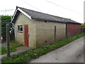
Kington Langley Telephone Exchange
Situated off Malmesbury Road (A350) this TE consists of two sections and has the code SSKLY. It provides telephone and broadband services to 636 residential and 61 non-residential premises in Kington Langley plus Kington St Michael nearby. The numbering range of this TE is (01249) 750xxx, the (01249) referring to the Chippenham group of ten TEs, and its postcode is SN15 5PY.
Image: © David Hillas
Taken: 26 Apr 2019
0.14 miles
7
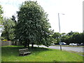
Sitting in front of the traffic
A wooden bench stands on a little patch of green right in front of the A350 (formerly the A429). It actually commemorates the centenary of Kington Langley Parish Council in 1994.
Image: © Neil Owen
Taken: 29 May 2021
0.15 miles
8
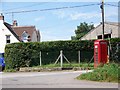
Telephone box near Kington Langley
K6 type telephone box near the Plough Inn.
Image: © Maigheach-gheal
Taken: 1 Jul 2009
0.15 miles
9
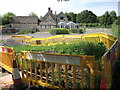
The Plough is being dug up
The inn has become subject to some heavy works near its back.
Image: © Neil Owen
Taken: 29 May 2021
0.16 miles
10
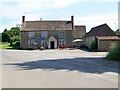
The Plough Inn, Kington Langley
The building dates back to the 1500s and its reputed that Oliver Cromwell stayed here on his way to attack Malmesbury.
The Plough remains one of the commonest pub names in regular use since at least the 16th century.
Image: © Maigheach-gheal
Taken: 1 Jul 2009
0.16 miles