IMAGES TAKEN NEAR TO
East Tytherton, CHIPPENHAM, SN15 4LT
Introduction
This page details the photographs taken nearby to SN15 4LT by members of the Geograph project.
The Geograph project started in 2005 with the aim of publishing, organising and preserving representative images for every square kilometre of Great Britain, Ireland and the Isle of Man.

There are currently over 7.5m images from over14,400 individuals and you can help contribute to the project by visiting https://www.geograph.org.uk
Image Map
Images are licensed for reuse under creativecommons.org/licenses/by-sa/2.0
Notes
- Clicking on the map will re-center to the selected point.
- The higher the marker number, the further away the image location is from the centre of the postcode.
Image Listing (8 Images Found)
Images are licensed for reuse under creativecommons.org/licenses/by-sa/2.0
Image
Details
Distance
1
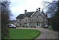
Pinnigers House
An impressive farmhouse in the small village of East Tytherton.
Image: © Roger Cornfoot
Taken: 12 Jan 2007
0.04 miles
2
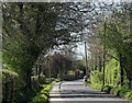
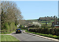
2011 : Maud Heath Causeway at East Tytherton
Heading west toward Chippenham.
Image: © Maurice Pullin
Taken: 8 Apr 2011
0.05 miles
3
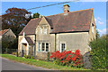
House in East Tytherton
Dwelling in east Thytherton.
Image: © Wayland Smith
Taken: 23 Oct 2016
0.05 miles
4
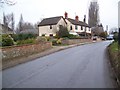
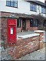
Housing in East Tytherton
There is an Edward VII postbox in the wall of the Old Bakery.
Image: © Maigheach-gheal
Taken: 1 Jan 2009
0.09 miles
5
Edward VII postbox, East Tytherton
The location of the postbox Image
Image: © Maigheach-gheal
Taken: 1 Jan 2009
0.10 miles
6
2011 : Maud Heath's Causeway at East Tytherton
Looking east, Bremhill is in the distance.
Image: © Maurice Pullin
Taken: 8 Apr 2011
0.21 miles
7
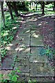
Moravian Burial Ground, East Tytherton
Pavement of grave markers in this small cemetery
Image: © Paul Buckingham
Taken: 24 May 2009
0.22 miles
8
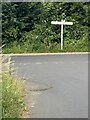
Road junction and signpost
The ‘T’ of this junction is Maud Heath’s Causeway. See Image
Image: © Alan Hughes
Taken: 15 Jul 2022
0.25 miles