IMAGES TAKEN NEAR TO
Bradenstoke, CHIPPENHAM, SN15 4EN
Introduction
This page details the photographs taken nearby to SN15 4EN by members of the Geograph project.
The Geograph project started in 2005 with the aim of publishing, organising and preserving representative images for every square kilometre of Great Britain, Ireland and the Isle of Man.

There are currently over 7.5m images from over14,400 individuals and you can help contribute to the project by visiting https://www.geograph.org.uk
Image Map
Images are licensed for reuse under creativecommons.org/licenses/by-sa/2.0
Notes
- Clicking on the map will re-center to the selected point.
- The higher the marker number, the further away the image location is from the centre of the postcode.
Image Listing (52 Images Found)
Images are licensed for reuse under creativecommons.org/licenses/by-sa/2.0
Image
Details
Distance
1
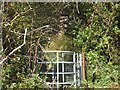
Kissing gate at the end of footpath from Bradenham
The path leads to Upper Town
Image: © David Smith
Taken: 18 Oct 2012
0.01 miles
2
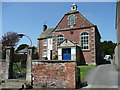
Providence Baptist Chapel, Bradenstoke
Built in 1777 and still in service
Image: © Jonathan Billinger
Taken: 6 May 2008
0.03 miles
3
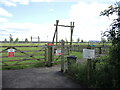
Bradenstoke recreation ground
Part of the Lyneham and Bradenstoke parish council's facilities.
Image: © Neil Owen
Taken: 28 May 2022
0.03 miles
4
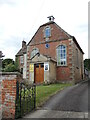
Providence Chapel, Bradenstoke
The Strict Baptist chapel was founded in 1777 and has a burial ground to the rear of the property. Built by Isaac Turner of Calne, it was adorned with a clock and bell of 1775, provided by John Broom of Castle Combe. The chapel is said to be the only one in Britain that has a bell to summon worshippers.
Repair work and restoration was needed and in 1928 £500 was raised to carry out the work; the bellcote rebuilt around 1960. With dwindling congregations, the church shut for a time in 1997 but was re-opened a year later.
Image: © Neil Owen
Taken: 28 May 2022
0.07 miles
5
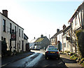
2010 : Bradenstoke village street looking west
"Bradenstoke is a village in Wiltshire, England situated to the north of the RAF Lyneham airbase and to the south of the River Braydon.
Originally lying within Braydon Forest, the "stoke" means "settlement". The parish itself is named Bradenstoke cum Clack, the latter being an ancient earthworks.
Largely consisting of a long, narrow, main street, it has 3 churches, one shop and a pub.
The former Bradenstoke Priory was founded in 1142 by Walter D’Evereaux, sheriff of Wiltshire, for the Augustinians. Having fallen into disrepair after the Dissolution of the monasteries, it was dismantled in 1930 to provide parts of a renovation of St.Donat's Castle, Wales, which had been bought by William Randolph Hearst."
The above was copied from: http://en.wikipedia.org/wiki/Bradenstoke
Image: © Maurice Pullin
Taken: 15 Nov 2010
0.07 miles
6
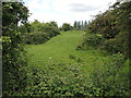
A Barrow and a motte
Clack Mount is an enigmatic ancient site. There are few solid details to draw from, but it appears to be a Bronze Age barrow mound, surrounded by later motte and bailey earthworks. Some writers have labelled the burial mound as Scufa's Barrow, and is mentioned in Anglo-Saxon documents, but this is not fully proven.
Its location close to the ruinous Bradenstoke Abbey suggests that some of the earthworks here are much later, even perhaps that the area was landscaped as a prospect in the eighteenth or nineteenth centuries. Certainly, there is a small mound that was built as a WWII pillbox.
Image: © Neil Owen
Taken: 28 May 2022
0.09 miles
7
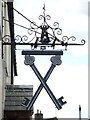
The Cross Keys
A large sign outside the pub.
Image: © Neil Owen
Taken: 28 May 2022
0.09 miles
8
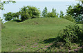
Clack Mount near Lyneham
A post-medieval prospect mount and World War Two pill box, more information at
http://www.pastscape.org.uk/hob.aspx?hob_id=212263
Image: © Rick Crowley
Taken: 23 Apr 2011
0.10 miles
9
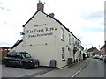
Need a lift home?
The Cross Keys Inn is the last surviving pub in Bradenstoke (The nearby Jolly Trooper Inn is now a private residence). Outside is what appears to be a taxi, with graphics. Do they do home deliveries of drinkers?
Image: © Neil Owen
Taken: 28 May 2022
0.10 miles
10
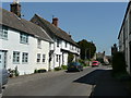
Bradenstoke village street
A mixture of cottages of different ages. On the shade side is the Cross Keys Inn.
Image: © Jonathan Billinger
Taken: 6 May 2008
0.10 miles