IMAGES TAKEN NEAR TO
Preston, CHIPPENHAM, SN15 4DY
Introduction
This page details the photographs taken nearby to SN15 4DY by members of the Geograph project.
The Geograph project started in 2005 with the aim of publishing, organising and preserving representative images for every square kilometre of Great Britain, Ireland and the Isle of Man.

There are currently over 7.5m images from over14,400 individuals and you can help contribute to the project by visiting https://www.geograph.org.uk
Image Map
Images are licensed for reuse under creativecommons.org/licenses/by-sa/2.0
Notes
- Clicking on the map will re-center to the selected point.
- The higher the marker number, the further away the image location is from the centre of the postcode.
Image Listing (6 Images Found)
Images are licensed for reuse under creativecommons.org/licenses/by-sa/2.0
Image
Details
Distance
1
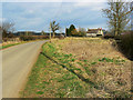
Near Thickthorn Farm, east of Preston
The 1:25K map shows two Thickthorn Farms at this location. The rather fine house shown here is the more easterly of the pair. It is just within this square. The 'Preston' in the title is the Wiltshire Preston, not to be confused with its less well-known namesake which is up north somewhere.
Image: © Brian Robert Marshall
Taken: 2 Mar 2009
0.08 miles
2
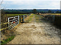
Farm track, near Preston
The track seems to be fairly new. It doesn't appear on the maps or aerial photos. It is situated between the two Thickthorn Farms shown on the 1:25K map.
Image: © Brian Robert Marshall
Taken: 2 Mar 2009
0.12 miles
3
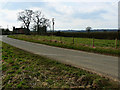
Thickthorn Cottages, near Preston
The cottages can be seen at the left. Preston itself is about a kilometre further on from here.
Image: © Brian Robert Marshall
Taken: 2 Mar 2009
0.19 miles
4
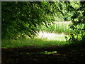
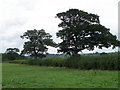
Footpath near Bushton
The footpath heads through the gap in the trees and makes its way around the edge of a field of maize.
Image: © Maigheach-gheal
Taken: 27 Aug 2010
0.23 miles

6
Hedge near Bushton
It is difficult to date hedges unless there is documentary evidence as to their planting, but one theory is to count the species in a 30 metre stretch and each species counts as a century. Only count older plants and not saplings.
Image: © Maigheach-gheal
Taken: 27 Aug 2010
0.24 miles