IMAGES TAKEN NEAR TO
Bowds Lane, CHIPPENHAM, SN15 4DS
Introduction
This page details the photographs taken nearby to Bowds Lane, SN15 4DS by members of the Geograph project.
The Geograph project started in 2005 with the aim of publishing, organising and preserving representative images for every square kilometre of Great Britain, Ireland and the Isle of Man.

There are currently over 7.5m images from over14,400 individuals and you can help contribute to the project by visiting https://www.geograph.org.uk
Image Map
Images are licensed for reuse under creativecommons.org/licenses/by-sa/2.0
Notes
- Clicking on the map will re-center to the selected point.
- The higher the marker number, the further away the image location is from the centre of the postcode.
Image Listing (11 Images Found)
Images are licensed for reuse under creativecommons.org/licenses/by-sa/2.0
Image
Details
Distance
1
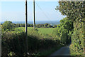
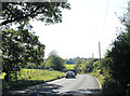
2011 : Down the hill on Bowd's Lane
Heading north west.
The A3102 Wootton Bassett road is a short distance behind the camera. A heat haze masks fields in the distance looking toward Malmesbury.
Image: © Maurice Pullin
Taken: 15 Oct 2011
0.04 miles
2
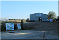
2011 : Pound Farm Shop near Lyneham
On the A3102 opposite Bowd's Lane.
Image: © Maurice Pullin
Taken: 15 Oct 2011
0.10 miles
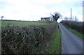
3
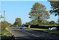
2011 : A3102 heading north east near the end of Bowd's Lane
Three miles from Wootton Bassett, then on to Swindon.
Image: © Maurice Pullin
Taken: 15 Oct 2011
0.14 miles
4
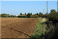
2011 : Ploughed field bordering the A3102
Seen from the end of Bowd's Lane.
Image: © Maurice Pullin
Taken: 15 Oct 2011
0.15 miles
5
2011 : A3102 heading south west to Lyneham
Just over half a mile to go then on to Melksham.
Image: © Maurice Pullin
Taken: 15 Oct 2011
0.17 miles
6
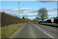
A3102 towards Wootton Bassett
Here called The Hillocks.
Image: © Robin Webster
Taken: 2 Feb 2018
0.17 miles
7

Footpath entrance, Bowd's Lane, near Lyneham
The footpath is at the top of a broad ridge running roughly south-west to north-east. To the right the slope leads down to a reservoir.
Image: © Brian Robert Marshall
Taken: 17 Mar 2009
0.19 miles
8
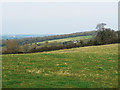
View north from a footpath, Bowd's Lane, near Lyneham
The slope leads down to the main railway to Bristol from Paddington.
Image: © Brian Robert Marshall
Taken: 17 Mar 2009
0.21 miles
9
Lillybrook house
A modern country house stands on the brink of a ridge, overlooking Dauntsey Vale.
Image: © Roger Cornfoot
Taken: 7 Jan 2007
0.22 miles
10
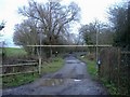
Fishery entrance
A former reservoir of the Wilts and Berks canal is now used as a venue for coarse fishing.
Image: © Roger Cornfoot
Taken: 7 Jan 2007
0.22 miles