IMAGES TAKEN NEAR TO
Riverside Drive, CHIPPENHAM, SN15 3XS
Introduction
This page details the photographs taken nearby to Riverside Drive, SN15 3XS by members of the Geograph project.
The Geograph project started in 2005 with the aim of publishing, organising and preserving representative images for every square kilometre of Great Britain, Ireland and the Isle of Man.

There are currently over 7.5m images from over14,400 individuals and you can help contribute to the project by visiting https://www.geograph.org.uk
Image Map
Images are licensed for reuse under creativecommons.org/licenses/by-sa/2.0
Notes
- Clicking on the map will re-center to the selected point.
- The higher the marker number, the further away the image location is from the centre of the postcode.
Image Listing (13 Images Found)
Images are licensed for reuse under creativecommons.org/licenses/by-sa/2.0
Image
Details
Distance
1
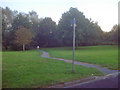
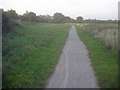
Cycleway off Riverside Drive
From Riverside Drive looking south at the point where the cycleway leaves the road.
Image: © Trevor Rickard
Taken: 9 Sep 2009
0.08 miles
2
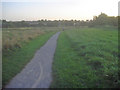
Cycleway at Monkton Park - 1
Looking south-west along the Avon flood plain as the path curves around the housing estate on the right. Housing at London Road on the horizon.
Image: © Trevor Rickard
Taken: 9 Sep 2009
0.10 miles
4
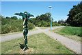
Signpost where paths cross
One of the distinctive signposts found on national cycle routes. This one is on the edge of Chippenham where Route 403 crosses a local footpath. https://www.sustrans.org.uk/ncn/map/route/route-403
Image: © Des Blenkinsopp
Taken: 4 Jul 2019
0.15 miles
5
Cycleway at Monkton Park - 1
Looking south-east. The river is just ahead in the trees.
Image: © Trevor Rickard
Taken: 9 Sep 2009
0.16 miles
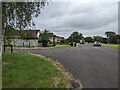
6
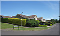
Riverside Drive, Chippenham
The eastern edge of Chippenham. These houses have a view over the River Avon.
Junction with Montague Close.
Image: © Des Blenkinsopp
Taken: 4 Jul 2019
0.18 miles
7
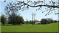
2011 : South along the Avon Valley east of Chippenham
A pleasant rural scene (apart from the power lines) but don't be fooled, a medium sized housing estate lies to the right. The River Avon hides between its banks.
Note the blackthorn (sloe) in flower.
Image: © Maurice Pullin
Taken: 8 Apr 2011
0.20 miles
8
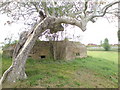
Pill Box in Monkton Park Pitch & Putt
A pill box which is now in the middle of the small golf course down by the river
Image: © chris morton
Taken: 7 May 2010
0.20 miles
9
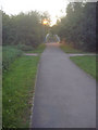
Approaching the Avon bridge
Carrying the cycleway over the river at Monkton Park.
Image: © Trevor Rickard
Taken: 9 Sep 2009
0.21 miles
10
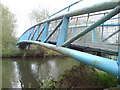
Bridge over the Avon at Monkton Park
This bridge carries the cycle/walkway over the river about half a mile upstream from the town centre.
Image: © chris morton
Taken: 7 May 2010
0.22 miles