IMAGES TAKEN NEAR TO
Westmead Lane, CHIPPENHAM, SN15 3HZ
Introduction
This page details the photographs taken nearby to Westmead Lane, SN15 3HZ by members of the Geograph project.
The Geograph project started in 2005 with the aim of publishing, organising and preserving representative images for every square kilometre of Great Britain, Ireland and the Isle of Man.

There are currently over 7.5m images from over14,400 individuals and you can help contribute to the project by visiting https://www.geograph.org.uk
Image Map
Images are licensed for reuse under creativecommons.org/licenses/by-sa/2.0
Notes
- Clicking on the map will re-center to the selected point.
- The higher the marker number, the further away the image location is from the centre of the postcode.
Image Listing (323 Images Found)
Images are licensed for reuse under creativecommons.org/licenses/by-sa/2.0
Image
Details
Distance
1
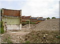
Waiting for new neighbours
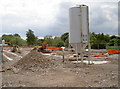
The old Hygrade Foods factories are all but a memory; further up the hill, some modern houses await to see what the new additions will look like when they join them. See Image] for more of the factory demolition.
Image: © Neil Owen
Taken: 30 Jun 2014
0.02 miles
2
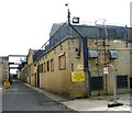
Hygrade Food Products - Westmead Lane
Image: © Betty Longbottom
Taken: 25 Aug 2008
0.03 miles
3
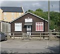
St John's Ambulance HQ - Westmead Lane
Image: © Betty Longbottom
Taken: 25 Aug 2008
0.03 miles
4
Out with the food, in with the homes
This is a view along Westmead Lane, now rather different today. Not so long ago it was a large industrial site, mainly occupied by Hygrade Foods (a meat products company), but they were sold to a Danish firm who consequently moved their operations elsewhere and left the area derelict. The local council have now approved the site to become a modern residential opportunity - but first the old factories have had to come down. See Image] for another view.
Image: © Neil Owen
Taken: 30 Jun 2014
0.04 miles
5
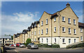
Louise Rayner Place
A new development near the town centre.
Image: © Des Blenkinsopp
Taken: 2 Jun 2021
0.04 miles
6

Gladstone Road and Westmead Lane
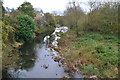
View from one of the back bedrooms of The Angel Hotel looking over car park and to the newish houses by the river in Westmead Lane. Westmead Lane runs along the river bank to playing fields which were the main venue of the Chippenham and District Sunday league. The lane ran through a meat processing factory which shut in 2007 and is now being redeveloped into retirement housing.
Image: © John Stephen
Taken: 29 Jun 2014
0.04 miles
7

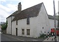
Sweet Briar Cottage
This attractive cottage is situated in Gladstone Road.
Image: © Michael Dibb
Taken: 24 Jun 2012
0.04 miles