IMAGES TAKEN NEAR TO
Malmesbury Road, CHIPPENHAM, SN15 1PR
Introduction
This page details the photographs taken nearby to Malmesbury Road, SN15 1PR by members of the Geograph project.
The Geograph project started in 2005 with the aim of publishing, organising and preserving representative images for every square kilometre of Great Britain, Ireland and the Isle of Man.

There are currently over 7.5m images from over14,400 individuals and you can help contribute to the project by visiting https://www.geograph.org.uk
Image Map
Images are licensed for reuse under creativecommons.org/licenses/by-sa/2.0
Notes
- Clicking on the map will re-center to the selected point.
- The higher the marker number, the further away the image location is from the centre of the postcode.
Image Listing (128 Images Found)
Images are licensed for reuse under creativecommons.org/licenses/by-sa/2.0
Image
Details
Distance
1
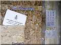
Enter with care
Would you enter this boarded up building - see Image]? With police dogs lurking?
Image: © Neil Owen
Taken: 7 Nov 2012
0.02 miles
2
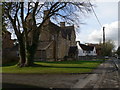
Parklands, Chippenham
Sheltered housing accommodation on Malmesbury Road.
Image: © Eirian Evans
Taken: 16 Feb 2011
0.03 miles
3
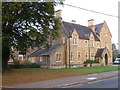
Grand house
A grand house once converted to flats but now sadly boarded up.
Image: © don cload
Taken: 16 Oct 2011
0.03 miles
4
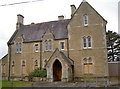
Closed to the public
But not completely closed! 'Parklands' is a mixture of buildings in this part of Chippenham that offers homes for the elderly. However, this older building is now boarded up. See Image] for a look inside the entrance porch that gives visitors a good excuse to leave quickly!
Image: © Neil Owen
Taken: 7 Nov 2012
0.03 miles
5
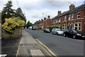
Chippenham, Malmesbury Road
Terraced houses near the town centre.
Image: © David Dixon
Taken: 16 Jun 2017
0.03 miles
6
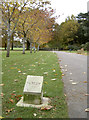
How much further? In imperial?
Another small stone alongside the path in John Cole Park. However, unlike the previous one, it is in metres not miles. See Image] for the stone marked in old money within a short distance and clear vision of this one.
Image: © Neil Owen
Taken: 7 Nov 2012
0.05 miles
7

Supported tree in John Coles Park
The tree must have fallen over when it was younger, but with the aid of some timber supports is still flourishing.
Image: © Stephen Craven
Taken: 16 Jul 2022
0.06 miles
8
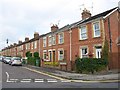
Ashfield Road, Chippenham
Part of a brick terrace of 22 houses, seen from Greenway Lane.
Image: © Derek Harper
Taken: 19 Jul 2011
0.06 miles
9
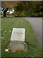
How much further to go?
A marker stone in John Cole Park, presumably giving distances to any passing joggers. See Image] for another just a short stagger up the path.
Image: © Neil Owen
Taken: 7 Nov 2012
0.06 miles
10
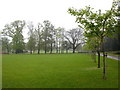
John Cole's Park
Looking north from the park entrance nearest to Chippenham centre.
Image: © richard noyes
Taken: 24 Apr 2003
0.06 miles