
IMAGES TAKEN NEAR TO
Broomfield, CHIPPENHAM, SN15 1DZ
Introduction
This page details the photographs taken nearby to Broomfield, SN15 1DZ by members of the Geograph project.
The Geograph project started in 2005 with the aim of publishing, organising and preserving representative images for every square kilometre of Great Britain, Ireland and the Isle of Man.

There are currently over 7.5m images from over14,400 individuals and you can help contribute to the project by visiting https://www.geograph.org.uk
Image Map
Images are licensed for reuse under creativecommons.org/licenses/by-sa/2.0
Notes
- Clicking on the map will re-center to the selected point.
- The higher the marker number, the further away the image location is from the centre of the postcode.
Image Listing (16 Images Found)
Images are licensed for reuse under creativecommons.org/licenses/by-sa/2.0
Image
Details
Distance
1
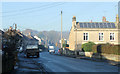
2010 : North on Greenway Lane, Chippenham
Mostly fairly modern housing with the exception of the house on the right with the solar panels which looks Georgian.
Image: © Maurice Pullin
Taken: 5 Dec 2010
0.10 miles
3
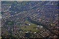
Wiltshire : Chippenham Scenery
Looking down to the town of Chippenham from a plane approaching Bristol Airport.
Image: © Lewis Clarke
Taken: 18 Jun 2017
0.20 miles
4
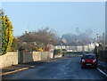
2010 : Birch Grove, Chippenham
Looking east from Greenway Lane.
Modern housing estate with well developed gardens. Probably built 1950's or 60's.
A little snow left from a recent fall, more to come.
Image: © Maurice Pullin
Taken: 5 Dec 2010
0.21 miles
5
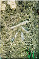
Chippenham, milestone
Ordnance Survey 1GL bolt benchmark on side of milestone (Chippenham 1) dating from 1856 when the survey line from Oxford to Bath was levelled. The mark is very unusual having its bolt inserted at the bottom of the LHS arrow cut, instead of at the level of the horizontal datum cut. For additional information on this and nearby benchmarks see the Bench Mark Database record http://www.bench-marks.org.uk/bm34234
Image: © Roger Templeman
Taken: 7 May 2010
0.23 miles
6
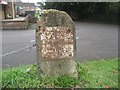
Old Milestone by the B4158, Malmesbury Road, Chippenham
Metal plate attached to stone post by the B4158 (was A429), in parish of Chippenham (North Wiltshire District), Malmesbury Road; 30m South of the junction with Hill Corner Road, outside King Alfred pub, on the verge, used as chain post, on East side of road. Chippenham plate, erected by the Malmesbury - First District turnpike trust in the 19th century.
Inscription reads:-
To
Chippenham
1
Carved benchmark left middle.
Milestone Society National ID: WI_CPMY01
Image: © M Faherty
Taken: 8 Jun 2008
0.23 miles
7
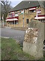
Old milestone on Malmesbury Road
On the B4158 is an old milestone, looking a little neglected. It still just about says one mile to Chippenham. However, it is also the place to find an unusual benchmark (see Image] ) - unusual not only because it is a 1GL boltmark, but also because the bolt is not aligned with the datum line. Sadly, the milestone's neglect has seen it topple slightly off its original level, rendering accurate levelling difficult (see Image]).
Image: © Neil Owen
Taken: 29 Feb 2012
0.23 miles
8
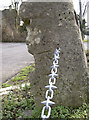
No longer level
A curious 1GL boltmark in a milestone on the Malmesbury Road - now shifted from its original position. Perhaps that may have something to do with the bolt not being aligned with the datum cut? See Roger Templeman's pic Image] for greater clarity or Image] for a wider view.
Image: © Neil Owen
Taken: 29 Feb 2012
0.23 miles
9
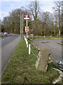
Leaning over
The old milestone on the Malmesbury Road is now not true to vertical. See Image] for a closer view.
Image: © Neil Owen
Taken: 29 Feb 2012
0.23 miles
10
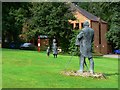
Greenways Business Park, Chippenham
William Henry Fox Talbot and his subjects stand in a green area in this relatively small business park. I believe the development dates from the 1990s.
Image: © Brian Robert Marshall
Taken: 8 Aug 2008
0.24 miles