IMAGES TAKEN NEAR TO
Grosvenor Road, SWINDON, SN1 4LU
Introduction
This page details the photographs taken nearby to Grosvenor Road, SN1 4LU by members of the Geograph project.
The Geograph project started in 2005 with the aim of publishing, organising and preserving representative images for every square kilometre of Great Britain, Ireland and the Isle of Man.

There are currently over 7.5m images from over14,400 individuals and you can help contribute to the project by visiting https://www.geograph.org.uk
Image Map
Images are licensed for reuse under creativecommons.org/licenses/by-sa/2.0
Notes
- Clicking on the map will re-center to the selected point.
- The higher the marker number, the further away the image location is from the centre of the postcode.
Image Listing (75 Images Found)
Images are licensed for reuse under creativecommons.org/licenses/by-sa/2.0
Image
Details
Distance
1
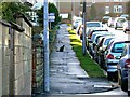
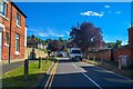
South along Grosvenor Road, Swindon
Large numbers of the many residential roads and streets in the centre of Swindon are subject to parking restrictions of one sort or another. Roads like this one south of Kingshill Road are for now unrestricted. How long that situation will obtain is unknown.
Image: © Brian Robert Marshall
Taken: 2 Jan 2014
0.02 miles
2
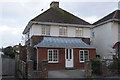
#8 Sunnyside Avenue
There is an OS benchmark Image on the right side of the house
Image: © Roger Templeman
Taken: 5 Jan 2012
0.06 miles
3
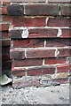
Benchmark on #8 Sunnyside Avenue
Ordnance Survey cut mark benchmark described on the Bench Mark Database at http://www.bench-marks.org.uk/bm40840
Image: © Roger Templeman
Taken: 5 Jan 2012
0.06 miles
4
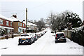
Sunnyside Avenue
Sunnyside Avenue in the snow.
Image: © Wayland Smith
Taken: 24 Jan 2021
0.07 miles
5

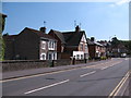
Grosvenor Road, Swindon
The large property at the left is in Kingshill Road Image The terrace of houses leading up the hill on the left of the road are pre-Great War, Edwardian or a little later. Beyond them the housing dates to between the wars.
Image: © Brian Robert Marshall
Taken: 19 Sep 2009
0.07 miles
6
Swindon : Hillside Avenue
Looking along Hillside Avenue off Kingshill Road.
Image: © Lewis Clarke
Taken: 14 Jul 2022
0.09 miles
7
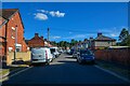
Swindon : Grosvenor Road
Off Kingshill Road.
Image: © Lewis Clarke
Taken: 14 Jul 2022
0.09 miles
8
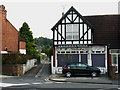
Shop and alley, Kingshill Road, Swindon
The shop used to be run by W W Nichols but has been closed for several years. I seem to recall that the family had several shops like this in the town but, like many others, they probably ceased trading with the rise of supermarket meat counters. The alley runs parallel with Grosvenor Road Image A fellow contributor with roots in Swindon advises that this shop was in business at around the time of the second world war.
Image: © Brian Robert Marshall
Taken: 19 Sep 2009
0.09 miles
9
Kingshill Road - western end
The group of houses seen here were all built in the 1920's by Edwin Blake builders, who were based at Rushey Platt House [the end of which just appears on the extreme left]. The houses were erected in part of the extensive gardens of the house and were mainly sold or rented out to relatives. The builders yard was situated between the main house and the canal with further gardens to the rear - now occupied by roads and dwellings in Erin Court.
Image: © Gordon Hatton
Taken: 3 Jun 2010
0.10 miles
10
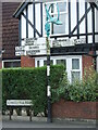
Direction Sign ? Signpost on the A4289 in Swindon
Located against the front garden wall of number 193 Kingshill Road on the south side of the mini roundabout at the junction of the A4289, William Street and Clarendon Lane, Central Swindon South parish. 4 arms and lamps. Moved to the Sunken Garden in the Town Gardens at approximately SU152834 in 2021, see https://www.facebook.com/SouthSwindonParish/posts/our-newest-heritage-feature-for-the-town-gardens-is-ready-to-open-this-1930s-roa/879737992690266/.
Milestone Society National ID: WI_SU1483A
Image: © John V Nicholls
Taken: 28 Jun 2009
0.10 miles