IMAGES TAKEN NEAR TO
North Colerne, CHIPPENHAM, SN14 8QZ
Introduction
This page details the photographs taken nearby to SN14 8QZ by members of the Geograph project.
The Geograph project started in 2005 with the aim of publishing, organising and preserving representative images for every square kilometre of Great Britain, Ireland and the Isle of Man.

There are currently over 7.5m images from over14,400 individuals and you can help contribute to the project by visiting https://www.geograph.org.uk
Image Map
Images are licensed for reuse under creativecommons.org/licenses/by-sa/2.0
Notes
- Clicking on the map will re-center to the selected point.
- The higher the marker number, the further away the image location is from the centre of the postcode.
Image Listing (6 Images Found)
Images are licensed for reuse under creativecommons.org/licenses/by-sa/2.0
Image
Details
Distance
1
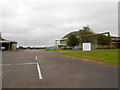
Old Hangars At Colerne Airfield
This airfield used to house an active RAF base but now it is mainly used by flying schools and Air Training Corps groups. The entrance is just off the old Fosse Way.
Image: © Nigel Mykura
Taken: 16 Sep 2012
0.08 miles
2
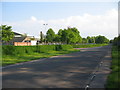
Fosse Way
A view looking south along the Fosse Way on the perimeter of Colerne airfield, an entrance to which can be seen at left.
Image: © Phil Williams
Taken: 11 May 2006
0.10 miles
3
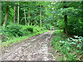
Track in Marshfield Wood
The track leads up the side of the valley containing the stream in this image Image The track is steeper than it looks.
Image: © Brian Robert Marshall
Taken: 27 Jun 2007
0.12 miles
4
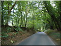
Fosse Way
This shows the line of the old Roman road as it heads north and starts to descend into the valley of the Doncombe Brook. The road also make its first significant deviation from a straight line after arriving on the high ground at Bannerdown above Batheaston 4km to the south.
Image: © Nigel Mykura
Taken: 16 Sep 2012
0.15 miles
5
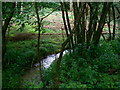
Small stream, Marshfield Wood
The stream lies in the middle of this private wood opposite Colerne Airfield. No-one about but plenty of evidence of forestry activities.
Image: © Brian Robert Marshall
Taken: 27 Jun 2007
0.18 miles
6
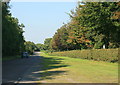
2008 : The Fosse Way near Colerne
It [the Fosse Way] runs from Exeter in the south west to Lincoln in the north-east, and was built in the middle of the 1st century AD. The word Fosse comes from the Latin word for ditch (Fossa) and is appropriate for this road as for a long time, the western boundary of Roman controlled Britain was protected by a defensive ditch running between Exeter and Lincoln. Whether the ditch was filled in and the road built later, or whether the road was built to follow the ditch is a subject of much conjecture. What is certain is that the road got its name from the ditch.
The above was copied from: http://www.rural-roads.co.uk/fosse/fosse1.shtml
Image: © Maurice Pullin
Taken: 26 Sep 2008
0.24 miles