IMAGES TAKEN NEAR TO
St. Martins Park, CHIPPENHAM, SN14 8PQ
Introduction
This page details the photographs taken nearby to St. Martins Park, SN14 8PQ by members of the Geograph project.
The Geograph project started in 2005 with the aim of publishing, organising and preserving representative images for every square kilometre of Great Britain, Ireland and the Isle of Man.

There are currently over 7.5m images from over14,400 individuals and you can help contribute to the project by visiting https://www.geograph.org.uk
Image Map
Images are licensed for reuse under creativecommons.org/licenses/by-sa/2.0
Notes
- Clicking on the map will re-center to the selected point.
- The higher the marker number, the further away the image location is from the centre of the postcode.
Image Listing (82 Images Found)
Images are licensed for reuse under creativecommons.org/licenses/by-sa/2.0
Image
Details
Distance
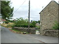
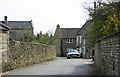
1
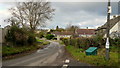
St. Martin's Lane, Marshfield
Looking north from the Sheepfair Lane junction.
Image: © Jonathan Billinger
Taken: 19 Nov 2013
0.04 miles
2
Broadley Villa
One of the charming houses in Marshfield and the footpath to Cold Ashton.
Image: © Neil Owen
Taken: 18 Oct 2016
0.04 miles
3
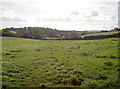
To Fuddlebrook?
A choice of paths here: one goes to the end of Marshfield, another to St Catherine's Brook near Cold Ashton, the third goes to Fuddlebrook. The brook valley stretches in front.
Image: © Neil Owen
Taken: 18 Oct 2016
0.04 miles
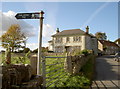
4
Cold Ashton 3km
A handily informative footpath sign near Broadley Villa, sending walkers down the valley (where one head of St Catherine's Brook rises) and then meeting up with the Limestone Link.
Image: © Neil Owen
Taken: 18 Oct 2016
0.04 miles
5
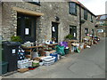
Charity sale on St Martin's Lane
Various household items are offered to passing buyers in aid of a good cause.
Image: © Neil Owen
Taken: 23 Jul 2022
0.07 miles
6
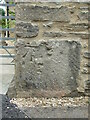
Benchmark on Ruxleigh Farm
An old mark on the corner of the farmhouse was made in the nineteenth century, but appears to be missing from the official Ordnance Survey list. See https://www.bench-marks.org.uk/bm175244 for the entry in the Benchmark Database and Image] for a wider view of the forgotten mark.
Image: © Neil Owen
Taken: 23 Jul 2022
0.07 miles
7
Ruxleigh on Sheepfair Lane
A farm building on the lane dates back a good few years and bears an original benchmark on the corner of the house. See Image] for a closer look.
Image: © Neil Owen
Taken: 23 Jul 2022
0.07 miles
8
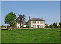
On the edge of Marshfield
A view looking north back towards Marshfield from the public footpath. A beautiful looking house with a wonderful view to the south.
Image: © Sharon Loxton
Taken: 11 May 2008
0.07 miles
9
2010 : St. Martin's Lane, Marshfield
Heading south from High Street toward St.Catherine's Valley.
Image: © Maurice Pullin
Taken: 10 Apr 2010
0.07 miles
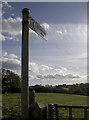
10
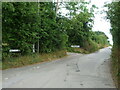
Leading up Fuddlebrook Hill
The sign for Gypsy Lane has the postcode on it, uncommonly.
Image: © Neil Owen
Taken: 23 Jul 2022
0.09 miles