IMAGES TAKEN NEAR TO
West Littleton Road, CHIPPENHAM, SN14 8NF
Introduction
This page details the photographs taken nearby to West Littleton Road, SN14 8NF by members of the Geograph project.
The Geograph project started in 2005 with the aim of publishing, organising and preserving representative images for every square kilometre of Great Britain, Ireland and the Isle of Man.

There are currently over 7.5m images from over14,400 individuals and you can help contribute to the project by visiting https://www.geograph.org.uk
Image Map
Images are licensed for reuse under creativecommons.org/licenses/by-sa/2.0
Notes
- Clicking on the map will re-center to the selected point.
- The higher the marker number, the further away the image location is from the centre of the postcode.
Image Listing (74 Images Found)
Images are licensed for reuse under creativecommons.org/licenses/by-sa/2.0
Image
Details
Distance
1
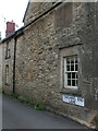
Touching End Lane
An old passageway in Marshfield with an unusual name.
Image: © Neil Owen
Taken: 23 Jul 2022
0.09 miles
2
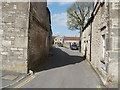
Marshfield, Touching End Lane
Lane off High Street; according to a local resident, named after two stone bollards (of which only the left remains), placed to warn coach drivers of potential problems.
Image: © Mike Faherty
Taken: 20 Apr 2010
0.09 miles
3
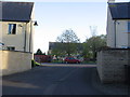
Tremes Close, Marshfield
Looking towards Tanners Walk and the children's play area. These houses date from around the turn of the millennium. The development is more sensitive than many, as local materials have been used and the street furniture is relatively elegant.
Image: © HelenK
Taken: 13 May 2012
0.10 miles
5
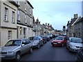
High Street, Marshfield
As in many historic villages in the South Cotswolds, the motor car tends to dominate the current-day scene.
Image: © Roger Cornfoot
Taken: 19 Jan 2007
0.10 miles
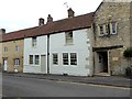
7

Sheepfair Lane, Marshfield
A view of cottages in Sheepfair Lane
Image: © Stephen Elwyn RODDICK
Taken: 11 Jul 2012
0.11 miles
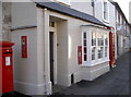
8
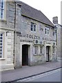
Public conveniences, Marshfield High Street
The offices of the parish council are on the first floor.
Image: © Roger Cornfoot
Taken: 21 May 2007
0.11 miles
10
Red on the High Street
Some familiar public communications, all a bright shade of red. The K6 telephone box (as is much of Marshfield, it seems) is Grade II listed.
Image: © Neil Owen
Taken: 18 Oct 2016
0.11 miles