IMAGES TAKEN NEAR TO
Down Road, CHIPPENHAM, SN14 8LQ
Introduction
This page details the photographs taken nearby to Down Road, SN14 8LQ by members of the Geograph project.
The Geograph project started in 2005 with the aim of publishing, organising and preserving representative images for every square kilometre of Great Britain, Ireland and the Isle of Man.

There are currently over 7.5m images from over14,400 individuals and you can help contribute to the project by visiting https://www.geograph.org.uk
Image Map
Images are licensed for reuse under creativecommons.org/licenses/by-sa/2.0
Notes
- Clicking on the map will re-center to the selected point.
- The higher the marker number, the further away the image location is from the centre of the postcode.
Image Listing (5 Images Found)
Images are licensed for reuse under creativecommons.org/licenses/by-sa/2.0
Image
Details
Distance
1
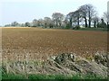
Farmland north of the A420, near Marshfield
The A420 is marked by the line of trees at the right. Star Farm can be seen near the left horizon.
Image: © Brian Robert Marshall
Taken: 22 Apr 2008
0.07 miles
2
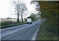
2008 : The A420 east of Marshfield
Heading toward Chippenham.
The old Bristol to Chippenham coach road passed this way. Obliterated long ago by the modern A420.
Image: © Maurice Pullin
Taken: 7 Nov 2008
0.09 miles
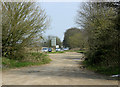
3
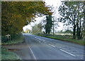
2008 : A420 near Marshfield
Opposite Down Road looking west toward Marshfield.
Image: © Maurice Pullin
Taken: 7 Nov 2008
0.09 miles
4
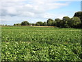
Farmland east of Marshfield
Star Farm is seen just left of centre. This is a similar view to Image, but at a different time of year.
Image: © David Purchase
Taken: 18 Sep 2013
0.14 miles
5
2010 : A420 layby near Marshfield
Looking east toward Chippenham.
The layby is a leftover bit of the A420 from when the bypass was built.
Image: © Maurice Pullin
Taken: 10 Apr 2010
0.24 miles