IMAGES TAKEN NEAR TO
Lower Street, CHIPPENHAM, SN14 8EU
Introduction
This page details the photographs taken nearby to Lower Street, SN14 8EU by members of the Geograph project.
The Geograph project started in 2005 with the aim of publishing, organising and preserving representative images for every square kilometre of Great Britain, Ireland and the Isle of Man.

There are currently over 7.5m images from over14,400 individuals and you can help contribute to the project by visiting https://www.geograph.org.uk
Image Map (Loading...)


Getting Data...Please wait
Leaflet Map data © OpenStreetMap
Images are licensed for reuse under creativecommons.org/licenses/by-sa/2.0
Notes
- Clicking on the map will re-center to the selected point.
- The higher the marker number, the further away the image location is from the centre of the postcode.
Image Listing (294 Images Found)
Images are licensed for reuse under creativecommons.org/licenses/by-sa/2.0
Image
Details
Distance
1
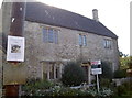
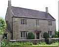
Have you seen Mr Tinkles?
The Old School House in Lower Street, open to offers.
Image: © Neil Owen
Taken: 21 Oct 2016
0.01 miles
2
![Dyrham houses [10]](https://s0.geograph.org.uk/geophotos/06/38/68/6386876_dc15eb76_120x120.jpg)
Dyrham houses [10]
The Old School House is 18th century with later alterations. Listed, grade II, with details at: https://historicengland.org.uk/listing/the-list/list-entry/1212609
Dyrham is thought to be the site of the Battle of Deorham fought in AD 577 when the West Saxons defeated the Britons of the West Country. At the edge of the village is Dyrham Park, a mansion set in 274 acres of parkland and owned by the National Trust.
Image: © Michael Dibb
Taken: 30 Oct 2019
0.02 miles
3
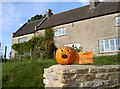
'I'm gonna a wall!'
Hallowe'en preparations are in hand in Dyrham.
Image: © Neil Owen
Taken: 21 Oct 2016
0.02 miles
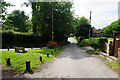
4
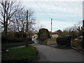
Lower Street, Dyrham
The Cotswold Way, day five 9:43am
Image: © Ian S
Taken: 21 Apr 2013
0.03 miles
5
![Dyrham houses [11]](https://s2.geograph.org.uk/geophotos/06/38/68/6386878_98311474_120x120.jpg)
Dyrham houses [11]
Old Post Office Cottage (nearest the camera) and Hillside Cottage in Lower Street.
Dyrham is thought to be the site of the Battle of Deorham fought in AD 577 when the West Saxons defeated the Britons of the West Country. At the edge of the village is Dyrham Park, a mansion set in 274 acres of parkland and owned by the National Trust.
Image: © Michael Dibb
Taken: 30 Oct 2019
0.03 miles
6
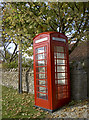
Dyrham Information
Looking suspiciously like an old telephone box. Inside you can glean bus timetables and exercise classes.
Image: © Neil Owen
Taken: 21 Oct 2016
0.04 miles
7
Old School House, Dyrham
Just to the west of Dyrham Park.
Image: © Rick Crowley
Taken: 20 May 2010
0.04 miles
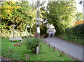
8
Lower Street, Dyrham
Quiet village lanes.
Image: © Bill Boaden
Taken: 20 Jul 2016
0.05 miles
9
The bottom of Sands Hill
A small grassy triangle at Dyrham's Upper and Lower Street. See Image] for a look at a horse trail marker.
Image: © Neil Owen
Taken: 21 Oct 2016
0.05 miles
10
![Dyrham houses [7]](https://s3.geograph.org.uk/geophotos/06/38/68/6386871_dbd3a82b_120x120.jpg)
Dyrham houses [7]
Lower Ledge Cottage and Honeysuckle Cottage are a pair of estate cottages dated 1863 on a central datestone. Another view of the cottages is at Image Listed, grade II, with details at: https://historicengland.org.uk/listing/the-list/list-entry/1212360
Dyrham is thought to be the site of the Battle of Deorham fought in AD 577 when the West Saxons defeated the Britons of the West Country. At the edge of the village is Dyrham Park, a mansion set in 274 acres of parkland and owned by the National Trust.
Image: © Michael Dibb
Taken: 30 Oct 2019
0.06 miles