IMAGES TAKEN NEAR TO
West Kington, CHIPPENHAM, SN14 7JE
Introduction
This page details the photographs taken nearby to SN14 7JE by members of the Geograph project.
The Geograph project started in 2005 with the aim of publishing, organising and preserving representative images for every square kilometre of Great Britain, Ireland and the Isle of Man.

There are currently over 7.5m images from over14,400 individuals and you can help contribute to the project by visiting https://www.geograph.org.uk
Image Map
Images are licensed for reuse under creativecommons.org/licenses/by-sa/2.0
Notes
- Clicking on the map will re-center to the selected point.
- The higher the marker number, the further away the image location is from the centre of the postcode.
Image Listing (46 Images Found)
Images are licensed for reuse under creativecommons.org/licenses/by-sa/2.0
Image
Details
Distance
1
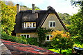
Thatched Cottage, West Kington, Wiltshire 2020
Image: © Ray Bird
Taken: 7 Oct 2020
0.00 miles
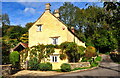
2
The Old Post Office, West Kington, Wiltshire 2020
Image: © Ray Bird
Taken: 7 Oct 2020
0.01 miles
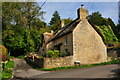
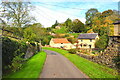
5
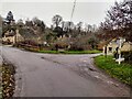
Wood Lane, West Kington
Looking down Wood Lane in West Kington, where it crosses the Broadmead Brook. The lane leading to West Kington Wick is on the right.
Image: © Kevin Pearson
Taken: 11 Dec 2021
0.02 miles
8
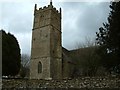
Church of St Mary the Virgin, West Kington
Image: © Colin Bates
Taken: 15 Feb 2006
0.03 miles
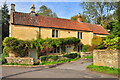
10
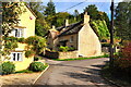
The Old Post Office, West Kington, Wiltshire 2020
Image: © Ray Bird
Taken: 7 Oct 2020
0.03 miles