IMAGES TAKEN NEAR TO
Whitegates, CHIPPENHAM, SN14 7HQ
Introduction
This page details the photographs taken nearby to Whitegates, SN14 7HQ by members of the Geograph project.
The Geograph project started in 2005 with the aim of publishing, organising and preserving representative images for every square kilometre of Great Britain, Ireland and the Isle of Man.

There are currently over 7.5m images from over14,400 individuals and you can help contribute to the project by visiting https://www.geograph.org.uk
Image Map (Loading...)


Getting Data...Please wait
Leaflet Map data © OpenStreetMap
Images are licensed for reuse under creativecommons.org/licenses/by-sa/2.0
Notes
- Clicking on the map will re-center to the selected point.
- The higher the marker number, the further away the image location is from the centre of the postcode.
Image Listing (34 Images Found)
Images are licensed for reuse under creativecommons.org/licenses/by-sa/2.0
Image
Details
Distance
1
Dunns Lane, Upper Castle Combe
Viewed across the B4039.
Image: © Jaggery
Taken: 24 Nov 2013
0.11 miles
2
![Castle Combe [1]](https://s2.geograph.org.uk/geophotos/05/28/51/5285186_a9af7c1f_120x120.jpg)
Castle Combe [1]
There is very limited parking available in the 'chocolate box' village of Castle Combe. This large car park is near the B4039 road, some half mile uphill from the village.
Image: © Michael Dibb
Taken: 14 Feb 2017
0.12 miles
3
![Castle Combe [2] - April Cottage](https://s3.geograph.org.uk/geophotos/05/28/51/5285187_bab25b25_120x120.jpg)
Castle Combe [2] - April Cottage
This delightful early 18th century cottage is listed, grade II, with details at: https://www.historicengland.org.uk/listing/the-list/list-entry/1283563
The 'chocolate box' village has over 50 listed buildings and there are over 25 listed monuments in the churchyard.
Image: © Michael Dibb
Taken: 14 Feb 2017
0.16 miles
4
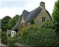
Castle Combe - April Cottage
The very pretty April Cottage is probably nearer Upper Castle Combe than the main village. It is unusual in being thatched, whereas all the other properties seemed to have stone roofs. It dates from the early C18th and is EH Grade II listed http://list.english-heritage.org.uk/resultsingle.aspx?uid=1283563&searchtype=mapsearch
Image: © Rob Farrow
Taken: 8 Sep 2013
0.17 miles
5
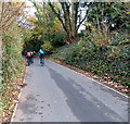
Cyclists in Upper Castle Combe
Cyclists ascend Dunns Lane towards the B4039.
Image: © Jaggery
Taken: 24 Nov 2013
0.17 miles
6
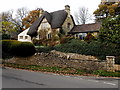
April Cottage, Castle Combe
Located near the SW end of Dunns Lane, the early 18th century thatched roof cottage was Grade II listed in 1960.
Image: © Jaggery
Taken: 24 Nov 2013
0.17 miles
7
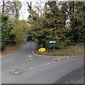
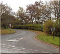
Junction in Upper Castle Combe
A sign directs all traffic to the left, to Dunns Lane which leads to a car park and the B4039. The road on the right also leads to the B4039, joining it about 200 metres SE of the point where Dunns Lane joins the B road.
Image: © Jaggery
Taken: 24 Nov 2013
0.18 miles
8
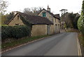
Hillside Cottage, Castle Combe
Viewed across The Street on the descent towards the centre of the village.
Image: © Jaggery
Taken: 24 Nov 2013
0.18 miles
10
![Castle Combe [4] - Hill Cottage](https://s1.geograph.org.uk/geophotos/05/28/51/5285189_0c7965ea_120x120.jpg)
Castle Combe [4] - Hill Cottage
This cottage is 18th century although the rear wing is probably 19th century. Listed, grade II, with details at: https://www.historicengland.org.uk/listing/the-list/list-entry/1199026
The 'chocolate box' village has over 50 listed buildings and there are over 25 listed monuments in the churchyard.
Image: © Michael Dibb
Taken: 14 Feb 2017
0.19 miles