IMAGES TAKEN NEAR TO
Hollis Gardens, CHIPPENHAM, SN14 6NS
Introduction
This page details the photographs taken nearby to Hollis Gardens, SN14 6NS by members of the Geograph project.
The Geograph project started in 2005 with the aim of publishing, organising and preserving representative images for every square kilometre of Great Britain, Ireland and the Isle of Man.

There are currently over 7.5m images from over14,400 individuals and you can help contribute to the project by visiting https://www.geograph.org.uk
Image Map
Images are licensed for reuse under creativecommons.org/licenses/by-sa/2.0
Notes
- Clicking on the map will re-center to the selected point.
- The higher the marker number, the further away the image location is from the centre of the postcode.
Image Listing (93 Images Found)
Images are licensed for reuse under creativecommons.org/licenses/by-sa/2.0
Image
Details
Distance
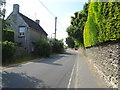
2
Luckington Village Hall
Located alongside the B4040, the hall was built of Cotswold stone in 1925 as a memorial to the men of Luckington who fought in the Great War. Luckington is a village in the southern Cotswolds in NW Wiltshire.
Image: © Jaggery
Taken: 17 Aug 2014
0.04 miles
4
![Path leaves the road [2]](https://s2.geograph.org.uk/geophotos/06/27/83/6278322_7b3c1116_120x120.jpg)
Path leaves the road [2]
The footpath leaves The Street and runs to Church Road.
Luckington is a village on the B4040 road between Malmesbury and Old Sodbury. The parish is on the county border with Gloucestershire.
Image: © Michael Dibb
Taken: 10 Aug 2019
0.06 miles
5
![Luckington houses [6]](https://s3.geograph.org.uk/geophotos/06/27/83/6278327_4974ab3c_120x120.jpg)
Luckington houses [6]
A glimpse of Luckington Manor. Built in the late 17th century with additions in the 20th century. The house suffered a major fire in 2012. Listed, grade II, with details at: https://historicengland.org.uk/listing/the-list/list-entry/1283149
Luckington is a village on the B4040 road between Malmesbury and Old Sodbury. The parish is on the county border with Gloucestershire.
Image: © Michael Dibb
Taken: 10 Aug 2019
0.06 miles
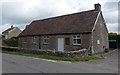
6
Polar Gardens bus stop in Luckington
The bus stop sign is on a small island at the junction of Polar Gardens and the B4040.
Image: © Jaggery
Taken: 17 Aug 2014
0.06 miles
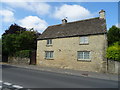
7
![Luckington houses [5]](https://s1.geograph.org.uk/geophotos/06/27/83/6278321_bbf226af_120x120.jpg)
Luckington houses [5]
Claremont is an early 19th century refronting of an older (possibly 16th or 17th century) house. Listed, grade II, with details at: https://historicengland.org.uk/listing/the-list/list-entry/1363814
Luckington is a village on the B4040 road between Malmesbury and Old Sodbury. The parish is on the county border with Gloucestershire.
Image: © Michael Dibb
Taken: 10 Aug 2019
0.07 miles
8
![Luckington features [3]](https://s3.geograph.org.uk/geophotos/06/27/83/6278319_a5cba421_120x120.jpg)
Luckington features [3]
Bell Field, a playing field and picnic site in the heart of the village.
Luckington is a village on the B4040 road between Malmesbury and Old Sodbury. The parish is on the county border with Gloucestershire.
Image: © Michael Dibb
Taken: 10 Aug 2019
0.08 miles
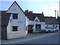
10
![Luckington houses [3]](https://s2.geograph.org.uk/geophotos/06/27/82/6278294_5d5c5b1d_120x120.jpg)
Luckington houses [3]
Bell House was an inn, now a private house. Built in the early 19th century with a later wing along the road frontage and a cottage beyond. See also Image Listed, grade II, with details at: https://historicengland.org.uk/listing/the-list/list-entry/1363813
Luckington is a village on the B4040 road between Malmesbury and Old Sodbury. The parish is on the county border with Gloucestershire.
Image: © Michael Dibb
Taken: 10 Aug 2019
0.10 miles