IMAGES TAKEN NEAR TO
Queens Crescent, CHIPPENHAM, SN14 0NF
Introduction
This page details the photographs taken nearby to Queens Crescent, SN14 0NF by members of the Geograph project.
The Geograph project started in 2005 with the aim of publishing, organising and preserving representative images for every square kilometre of Great Britain, Ireland and the Isle of Man.

There are currently over 7.5m images from over14,400 individuals and you can help contribute to the project by visiting https://www.geograph.org.uk
Image Map (Loading...)


Getting Data...Please wait
Leaflet Map data © OpenStreetMap
Images are licensed for reuse under creativecommons.org/licenses/by-sa/2.0
Notes
- Clicking on the map will re-center to the selected point.
- The higher the marker number, the further away the image location is from the centre of the postcode.
Image Listing (4 Images Found)
Images are licensed for reuse under creativecommons.org/licenses/by-sa/2.0
Image
Details
Distance
1
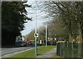
2009 : Looking north on Hungerdown Lane, Chippenham
Part of Chippenham's partial inner ring road with a timely warning to drivers with lead in their shoes.
Image: © Maurice Pullin
Taken: 16 Feb 2009
0.11 miles
2
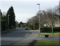
2009 : Queens' Crescent, Chippenham
That is how it is spelled on the sign, with the apostrophe after the s.
Image: © Maurice Pullin
Taken: 16 Feb 2009
0.13 miles
4
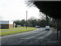
2009 : Looking south on Hungerdown Lane, Chippenham
Along with Saltersford Lane to the south and Hardenhuish Lane to the north Hungerdown Lane gives Chippenham half of an inner ring road.
Image: © Maurice Pullin
Taken: 16 Feb 2009
0.20 miles